Thursday, October 6, 2016

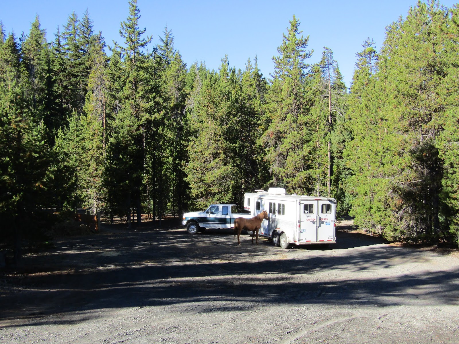
Chief Paulina Horse Camp, Deschutes National Forest, Oregon

Chief Paulina is located in the Newberry National Volcanic Monument. There are two large lakes (Paulina and East) inside the caldera and there are resorts with restaurants at both lakes.
The Crater Rim trail is 21 miles long and runs around the entire caldera, and can be done as one long ride, or there are ways to make shorter loops.This volcano is active! Something to ponder as you are riding past the evidence of past eruptions.

Looking down on Paulina Lake from the Crater Rim Trail.

To get there: From Bend drive 20 miles south on Hwy 97, take a left on Paulina Lake Rd, there will be a sign for Newberry. Follow this paved road for 14 miles and look for the horse camp sign on the right.

Once you get to the welcome station/ fee booth, you can show them your NW Forest Pass, or pay $5.00 for entry if you are just going for the day. They will also give you a brochure with a map.

Chief Paulina has 14 sites that are reservable with either 2 or 4 horse steel corrals that are $14.00 and $18.00 per night respectively. There is a bathroom, a waste water dump, and a garbage bin. There is water for stock only, that comes from a large tank, and a big manure bin, both of which are in the day use area. The spots are all back in and not all of them are large enough for bigger rigs, spot #10 is the most roomy. No dispersed camping is allowed in this area. Mosquito's can be fierce here in the early summer. Update: The camp has had a remodel and has some pull through spots now and effort has been made to enlarge areas to accommodate larger rigs. There is also a second water tank near the end of the loop.

Chief Paulina Horse Camp.

Chief Paulina Horse Camp.

One of the stock water tanks.

The camp is not gated and you can still park and ride there up until they close the whole place down in winter. The bathroom is now locked, but there are two other older bathrooms you can still use, and they are located right before the start of the trailhead.


To do the north side of the rim, leave camp following the trail between sites 8 and 10, and take a right on the Newberry Crater Trail.

The day use area.

Trails are well marked.

On the first part of the ride you will be following the power lines for just over a mile. Once you reach the junction with the Crater Rim Trail you will be right next to the main paved road, cross it, then cross the bridge, and the trailhead for the north side of the rim is behind the green gate.

The trail under the power lines.

Cross the bridge to get to the north side of the rim's TH.

Follow the wide Crater Rim trail up the hill. This is also where the Peter Skene Ogden trail starts. But more about that option later...
You will climb uphill for awhile through the forest and then it opens up and you will get some great views down onto Paulina Lake. Cyclists also use these trails so you may run into them on the rim, but on the Peter Skene Ogden trail they are only allowed to ride it uphill, they have to take an alternate route down.

 Sign by the green gate to get to these TH's.

On the Crater Rim Trail.

Paulina Lake and Paulina Peak from the Crater Rim Trail.

After awhile you will pass the junction to Swamp Wells Horse Camp .You can ride to here from Swamp Wells, which is a 20 mile total out and back trip. At the next junction if you take a right and switchback downhill towards Cinder Hill Campground you can cut the ride short and head back on the Newberry Crater Trail, and it will skirt around East Lake and eventually back to where you started.

On the Crater Rim Trail.

Or if a longer ride is preferable continue on, the next junction is gravel road 21, the Parallel Trail runs downhill beside it....but this is not any shorter than just continuing on until you get to the Lost Lake Trail. Along this next section you can see Fort Rock way off in the distance.


The Lost Lake Trail is a fun way to go back because you will pass by Pumice Flat, which is a large nearly treeless area filled with pumice. Once you reach the end of the flat stay to the right. This winds it's way downhill past the Big Obsidian Flow and more views of Paulina Lake and the Three Sisters. Once you get to the bottom take a left on the well used Newberry Crater Trail once again, and this will take you back to camp.

East Lake from the Crater Rim Trail.

Pumice Flat from the Lost Lake Trail.

Views from the Lost Lake Trail.

Hard to capture the shininess of Obsidian with a camera.

Another fun ride to do is to take the Crater Rim Trail south up to Paulina Peak which looms directly above camp. Tourists that aren't into hiking can just drive up to the peak and look around. There is a spur trail with an area that is cliffy near the top, and in fact you are not supposed to ride horses along that section, but you can bypass it. The trail then crosses over the road and from here you could take a quick detour up to the parking area to see the view. Then go back to the trail and continue, returning along the Lost Lake Trail to make a nice loop.

Paulina Peak.

On the Lost Lake South Trail.

It's bad karma and illegal to take any of the Obsidian.

The Big Obsidian Flow along the Newberry Crater Trail.

The Peter Skene Ogden trail is another ride option leaving from behind the green gate across the bridge as mentioned before. It runs 8.5 miles one way downhill alongside Paulina Creek to the parking area and trailhead by the Ogden Group Camp.

One of the waterfalls on the Peter Skene Ogden Trail.

On the Peter Skene Ogden Trail.

There is also the Paulina Lakeshore Loop Trail which is not a horse trail, but makes for a really nice 8 mile hike. There are several other shorter hikes, the best ones are over to see Paulina Falls or to hike across the Obsidian Flow. There are also some hot springs, and of course water sports and swimming. So there are plenty of other things to do in between rides!

Paulina Lake from the lake shore loop hiking trail.


Happy Trails!


GPS COORDINATES TO CHIEF PAULINA


Saturday, October 1, 2016

Cabot Lake to Table Lake, Mt. Jefferson Wilderness, Oregon

Sadly there is not too much time left to get into the high country this year. Awhile back a friend asked me if I had ever done the ride to Table Lake, and my answer was no. I had gone part of the way once, on a not so great weather day, with a lot of cloud cover, and I hadn't been back since. So it was time!

Above Carl Lake on the Cabot Lake Trail.

To get there: From Sisters go 12 miles west on Hwy 20, take a right at the sign for Wilderness Trailheads and Jack Lake Rd. Follow it for 4.4 miles, then take a left on Rd. 1230, it will turn to gravel after 1.5 miles at a junction, stay on 1230 which is to the right, and follow it another 7 miles until it ends at the Cabot Lake Trailhead.
The gravel part of Rd 1230 is rocky in places, one lane, with some washboard and has gotten worse in recent years.
The trailhead is not huge, but you can still turn around and park even if there are some cars in the lot.

This trail starts through the old burn area from the B&B fire of 2003 with views of the top of Mt. Jefferson peaking above the other ridges and buttes. Full of Manzanita and Snowbrush this area is always green and pretty. If it is a windy day don't be surprised if you hear something that sounds like screaming. The wind whistles through the dead trees and they make some very ghostly sounds.


The parking area at the Cabot Lake Trailhead.

At the start of the Cabot Lake Trail.

Along the Cabot Lake Trail, Green Ridge in the distance on the right.

The first junction you will get to is the short detour that goes over to Cabot Lake, which you can check out very quickly. On this particular day that trail was not cleared, so I skipped it. You can view the lake from above a little later as you continue to switchback up the trail.
There are a few other ponds and small lakes along the the way until you get to the much bigger Carl Lake.

A small lake along the Cabot Lake Trail.

After checking out Carl Lake which is lovely and very swimmable, the trail continues on beside the lake shore. You will see another junction to the left that goes towards Shirley Lake and the PCT, ignore it and stay straight, towards Junction Lake. The trail then switchbacks up above Carl Lake.

Carl Lake.

On the switchbacks above Carl Lake on the Cabot Lake Trail.

Once you get to Junction Lake, which is more of a pond, the old Sugar Pine Ridge Trail that is no longer maintained, leaves to the right from here, but just stay on the very obvious main trail.
This is where things start to get really interesting, you will come to a large lava field with Forked Butte on the right and North Cinder Peak on the left, and some fabulous Mt. Jefferson views.

Riding past the lava flow on the Cabot Lake Trail.

Shale on the Cabot Lake Trail.

Getting closer to Mt. Jefferson.

North Cinder Peak.

Mt. Jefferson.

Bear Butte in the distance.

After this scenic section the trail drops downhill into the forest and eventually you will reach Patsy Lake. At Patsy Lake there is another trail heading down to the right, but it goes to Jefferson Lake. There is a sign pointing out that this trail is not maintained. I would heed that warning, even hikers have a difficult time attempting it these days. Update: The Jefferson Lake Trail has been cleared for the first time in 14 years and I have since ridden it from the lower trailhead.

Patsy Lake.

Forked Butte.

Fall colors on the Cabot Lake Trail.

The main trail switchbacks yet again uphill for a short while to the next destination which is Table Lake. There are no views of Jefferson from down by this lake. I stayed here for a brief break and then turned around and headed back.

Table Lake.

Hanging out at Table Lake.

This was an 18.2 mile ride according to my map, but it seemed longer, you can't move out very fast for a lot of the ride, and so time wise it wasn't a normal 18 miler. From what I understand the trail continues briefly past Table Lake, and may not be cleared from there, but I didn't attempt it.

Heading back on the switchbacks above Patsy Lake.

Patsy Lake from above.

Happy Trails!


GPS COORDINATES TO CABOT LAKE TH

Tuesday, September 20, 2016

South Breitenbush and Triangle Lake Equestrian Camp, Oregon

I have to admit the main reason I wanted to camp at Triangle was to do the ride into Jefferson Park from the S. Breitenbush Trailhead which is located on the way to the camp (if coming from the south).

Mt. Jefferson and Scout Lake.

Although I have hiked into here before from the Whitewater Trailhead, I wanted to revisit and check out the whole area on horseback. There are a few different trailheads that provide access, but most are not horse trailer friendly so S. Breitenbush was the best option.

S. Breitenbush Trailhead.

This trail gradually climbs almost 3000 feet in elevation in 6 miles, and it becomes pretty rocky in the middle section. Update: This trail has since burned in a fire and sadly does not look like this anymore.

On the S. Breitenbush Trail.

Once I got close to the mountain there were a lot of pretty little meadows and creeks. Then the trail met the PCT and I was right next to Russell Lake.

Mt. Jefferson on the S. Breitenbush Trail.

I wandered around for awhile, checking out Scout Lake, Bays Lake, and Park Lake.

Scout Lake and Mt. Jefferson.

Park Butte.

After awhile I had to leave this beauty behind, head back down and continue the drive over to Triangle. The first part of the road into camp is paved, but the last four miles are gravel and it is a rough potholed road. This is the Olallie Lake Resort and there are numerous other campgrounds for people, but the horse camp is one of the first that you come to, located 3 miles from Olallie Lake. Once this resort is closed for the season, they shut the gate and you can no longer get in to any of the camps.

Triangle Lake Equestrian Camp is a large half circle with 8 spots with log corrals. The spots are quite roomy with most being large enough for bigger rigs, although they are all "back in" only.
There is a bathroom, three manure bins, a garbage can, and a very large water storage container that is for stock, no potable water. It is $15.00 per night and the camp is managed by the resort.
There is quite a bit of traffic going to and fro along the main road and people, that are always driving entirely too fast, kick up a large cloud of dust which then hangs in the air and drifts through camp for quite some time.

Triangle Lake Equestrian Camp. 

The stock water tank at Triangle Lake Equestrian Camp.

The actual Triangle Lake is just a very short stroll behind the camp, but is off limits for horses. At this time of year, it is more of a large puddle, not deep enough for swimming.

Triangle Lake and Olallie Butte.

On my second day I headed over to the PCT which is a short jaunt away, and rode south, back towards Jefferson Park again except it would be a rather long ride to do from camp, 29 miles round trip. This country has A LOT of lakes, I rode past Head Lake which is right next to Olallie Lake, and is a good one for swimming. Olallie Lake is off limits for swimming because they use it for drinking water. I then continued to Cigar Lake and Upper Lake and then about half a mile further to a meadow, and then I turned around. On my way back I visited a side trail to Top Lake. There is also a trail that climbs Olallie Butte, which I did not do. Looking it up online later, it has an interesting story, the last part of the climb ends up on the Warm Springs Indian Reservation. You are not supposed to hike/ride on Indian land without permission, with the exception being the PCT. I guess the Indians have removed the original trailhead signs (there are some new handmade ones) to discourage people from hiking the butte, but obviously everyone is continuing to do so.

Head Lake is right near Olallie Lake and looks great for swimming, there is even a floating dock.

Olallie Lake from the PCT.

Cigar Lake.

On the PCT.

 Mt. Jefferson looks so close, but it isn't!


Top Lake and Olallie Butte.

It was nice to be riding in an area where I knew for a fact that the trails would be cleared, especially this particular year, with the winter having wreaked havoc on most trails, and not enough manpower to get all of them logged out. OET clears the Lodgepole Trail every year in July, and also a part of the PCT, and the Muleskinners maintain this section of the PCT as well.

Sign on the PCT.

The guard station cabin at Olallie Lake Resort. This can be rented.

On the third day I rode the PCT north, this is a very easy stretch of the trail that passes Jude Lake then runs along a ridge for awhile with occasional views of Mt. Hood, then drops down to Lemiti Creek which is currently dry, and into the Warm Springs Indian Reservation. Again I rode as long as I felt like going before heading back.
The PCT can be a busy trail but I saw no one on the way out, and only a few hikers on the way back.

Fall colors on the PCT.

Standing in Lemiti Creek, which is currently dry.

Heading north on the PCT.

Mt. Hood from the PCT.

My evenings at camp were uneventful, seeing as how I was the only person camped there.
The next morning was cloudy and I figured I would get rained on at some point, and indeed I did for a short time.
I did the Lodgepole Trail which heads south for awhile then climbs up to several lakes. I passed Lower Lake, then did a side trail over for a view of Fish Lake, then Middle Lake and then I got to the junction with the Red Lake Trail and decided rather than turn around and go back the same way, I would just follow it back to the PCT and ride that section once again. When I arrived at the resort, I took the road home this time for a change of scenery.

The Lodgepole Trail.

Looking down onto Fish Lake.

Stopped for a snack at a small pond on the Red Lake Trail.

There were still even more lakes I could have visited and a few other options for making some loops, so there is plenty of exploring to do in this area.
Driving back down in elevation, it was pouring rain, and there was a bike race going on with drenched cyclists to dodge. I love the greenery on the west side, but I'm always glad to get back home to the desert, where the rain does not dare to fall!


GPS COORDINATES TO S. BREITENBUSH TH

GPS COORDINATES TO TRIANGLE