I have a long list of horse camps to visit, and I will get to them all eventually! When I saw that both of these areas had trails that were cleared, I decided to head over to Washington.
The Icicle Creek Road to camp can be pretty busy, but people tend to mostly congregate in certain areas by the river, so by the time I got to Black Pine it was deserted, and I had left all the crowds behind. The last five miles are gravel and there are some washboard sections but all in all, it is a good road.
Black Pine has 14 pull through spots, with either high line poles and/or trees and hitching rails. Most of the spots aren't particularly level, #10 is the flattest, but this is a good camp to get larger rigs into. There are two bathrooms, a dumpster, a solar powered well with potable water, (the water comes out slowly but all you have to do is push a button, as opposed to the full body work out I have gotten, using hand pumps at other camps. Also someone has thoughtfully put a large tree branch next to it, so you can lean the branch against the button, instead of getting a cramp in your thumb.) Update: As of 2023 the well has run dry.
There is also a small creek, just a short way down the Jack Pine Trail that leaves from camp.
There is no manure bin, it's $16.00 per night and there are signs stating it is for horse campers only.
There is a day use area across the street with a loading ramp and hitching rail, since there isn't enough room to park trailers where the road ends at the Icicle Creek Trailhead.
 |
| Black Pine is trying to keep the non horse campers away. |
 |
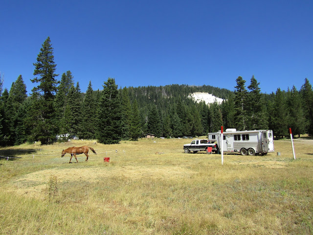
| Site # 13 at Black Pine Horse Camp. |
 |
| The solar powered well. |
I have several different horse trail books, and a map of the area, but as I learned on my first day, there are three easy to moderate trails that get the most obvious use, and most people do out and back rides, although loops can be made. Then there are some very steep trails that in years past were once used predominately by stock, but that nobody seems to ride anymore. I was hoping to try to do a little bit of both, but wasn't sure about the condition of the harder trails. Even if someone just wanted to do the three easiest trails, you can ride all day on them, this is a vast area with plenty of options, and all the junctions are marked.
I started on the Jack Creek Trail ( almost all of the trails are named after a creek, or sometimes a ridge) and followed it to the Meadow Creek Trail. It seems like most people turn around and go back from there and/or pack in and stay the night in the beautiful meadow, but there is a way to do a 22 mile loop, following the French Creek Trail back to camp, so that is what I did. In order to see a little more varied scenery you have to do some long rides, and the middle section of this loop was the most scenic.
 |
| The bridge over Jack Creek. |
 |
| On the Jack Creek Trail. |
 |
| On the Meadow Creek Trail. |
 |
| Harding Mt. on the Meadow Creek Trail. |
Although people from BCH have worked very hard to clear trails in recent years, there was a section when I reached the upper part of the French Creek Trail where I had to go around some downed logs. There is no shortage of water on this ride, from some muddy/boggy areas, to small streams, to large creek crossings, some of which were a little more technical. This was a 9.5 hour day, mostly because there is not a lot of opportunity to move out very fast.
 |
| On the Meadow Creek Trail. |
 |
| On the French Creek Trail. |
 |
| A lot of bunnies back at camp. |
The following day I did about 16 miles starting on the easy and pretty much level Icicle Creek Trail. You can follow it all the way to the PCT, which would be a long ride, or try some of the other side trails that veer off. Just for kicks and giggles I followed the obviously underused Leland Creek Trail for awhile. Crossing Leland Creek, the water was up to my horse's belly which makes it clear why not many hikers are using it, since they would have to wade. Otherwise the trail was actually in good shape, at least for as far as I went.
 |
| A waterfall in Icicle Creek. |
 |
| A lot of old growth forest on the Icicle Creek Trail. |
 |
| This bridge on the Icicle Creek Trail was very warped and sagged off to one side, but was solid. |
 |
| Crossing Leland Creek. |
 |
| Heading back along the Icicle Creek Trail. |
That evening a group of horse ladies came in and camped, but otherwise no one else arrived even on Friday night. On the three riding days I did at Black Pine, I saw a total of three hikers the first day, one on the second day, and one on the third. So this is not an extremely busy trail system.
The next day didn't quite go as planned, I retraced my steps up the Jack Creek Trail with the idea that I would try to ride the Trout Creek Trail to Trout Lake. When I got to the junction there was a backpacker and his dog sitting on the ground taking a break. I asked him if the trail was clear, he said it was, then asked if horses had to be taught to do those kind of trails. I assumed he was a non horse person who may just not know what horses are capable of, but I still asked what the trail was like. As his silly and completely uncontrollable dog ran around my horse in circles, trying to nip her, and barking the entire time, the guy told me the trail had some red tape at sections where it had eroded, you could lose your foot over the edge, and there were some deep holes. So I decided to skip that and ride all the way back up to the Meadow Creek Trail, and do the Snowall Cradle Trail instead.
As I rode away, the dog followed me and wouldn't go back to his owner, so I had to turn around so the guy could grab the dog. My horse is very polite and does not kick, but that dog will be in big trouble in the future, if he runs into a different kind of horse.
 |
| Back at the meadow on the Meadow Creek Trail. |
 |
| The junction at the meadow for the Snowall Cradle Trail. |
The Snowall Cradle Trail climbs very steeply for over a mile and a half to the top of a ridge, but once you are at the highest point, it drops down again and the next mile or so continues to Cradle Lake and beyond. I would have liked to have at least seen the lake, but I didn't know how rough the rest of the way would be, and it's probably a good thing I didn't continue, since this was another 9 hour ride and I probably wouldn't have gotten back to camp until after dark. Also this was a warmer day and although my horse doesn't normally sweat much, after that climb she looked like she had gone swimming in a lake.
 |
| Jack Ridge from the Snowall Cradle Trail. |
The next day, a Saturday, I left Black Pine and drove over to Conrad Meadows, outside of Naches WA. Although I have been into the Goat Rocks Wilderness before from
Walupt Horse Camp, this is another way to access a section of it. The road to the trailhead/camp is gravel for the last 7 miles and is not very washboard, but has some potholed sections.
Conrad Meadows is a large meadow on a bit of a hill, with quite a few high line poles set up in the grassy areas, and plenty of trees to use for high lining in the other areas. The South Fork Tieton River is the water source, and the spots with the easiest access are on the far right hand side. There is a bathroom at the trailhead and two porta potties in the camping area. The road running through the meadow is quite rutted, but you can get to the bottom easier by staying on the left of the loop. Any sized rig can fit into this camp. There is no manure bin, and no fee for camping.
Conrad Meadows is actually on private land but the landowners have an easement with the forest service, so people can camp and ride or hike from this area. This was a busy place when I arrived, and it was a very hot day, but all the good shady sites were taken down by the river, so I pulled into a grassy spot and made myself at home.
 |
| Conrad Meadows, Sunday night after everyone had left. |
 |
| Conrad Meadows. |
That evening an older fellow named George came over to say hi, we got to chatting, and the next thing I know I was eating some watermelon in his trailer.
The next day my plan was to do the ride to Surprise Lake on the South Fork Tieton Trail. I hadn't gotten very far down the trail before I heard a horse neighing behind me, and found out George was high tailing it to catch up with me. His riding buddy had had to leave the day before, so he was going it solo.
This is an 11.4 mile loop climbing up about 1600 feet to the lake which is a lovely turquoise color.
George was wanting to check out a user trail to see if it was passable, but by the time we got there it was clear that his horse was all tuckered out, so he skipped that section, and we ended up riding together the whole day.
 |
| The road is gated, since it is private land, but two of the trailheads leave from behind the gate. |
 |
| Surprise Lake on the South Fork Tieton Trail. |
 |
| Lunch break on the South Fork Tieton Trail. |
 |
| Saw this nonchalant elk on the South Fork Tieton Trail. |
Had I been alone I would have climbed higher in elevation, because that is where some other trails lead into the gorgeousness of the Goat Rocks to Warm Lake and beyond with waterfalls, other lakes, and plenty of mountain peaks. George had just done that ride the day before, so perhaps I will have to go back and check that out another time.
Continuing the loop, there is a narrow shale section, a washout section, and also a bridge that has collapsed, but that you can still ride over safely.
 |
| George, almost back to camp. |
 |
| Goat Rocks views from the meadow. |
 |
| George crossing the South Fork Tieton River. |
My new friend George packed up and headed home that afternoon, and by late in the day I was the only horse person left at camp. Just one nice, quiet group of non horse campers remained.
It got mildly stormy that night, which was nice because it cooled things down quite a bit.
The next day I needed to drive home, but I wanted to do one more ride, so I was on the trail by 6:00 am. The Ten Day Trail heads up to Cirque Lake, and you can make it into a loop by coming back down Road 1000.
I don't know what the mileage is, but it was the shortest ride I did on the whole trip, about 5 hours including riding partially around the lake and stopping for a snack break. You could also do it just as an out and back and the road version would be a little less work for your horse. This is not actually in the Goat Rocks Wilderness, but there are some views over to Gilbert Peak and Tieton Peak.
 |
| At the junction of the South Fork Tieton Trail and the Ten Day Trail. |
 |
| Cirque Lake. |
 |
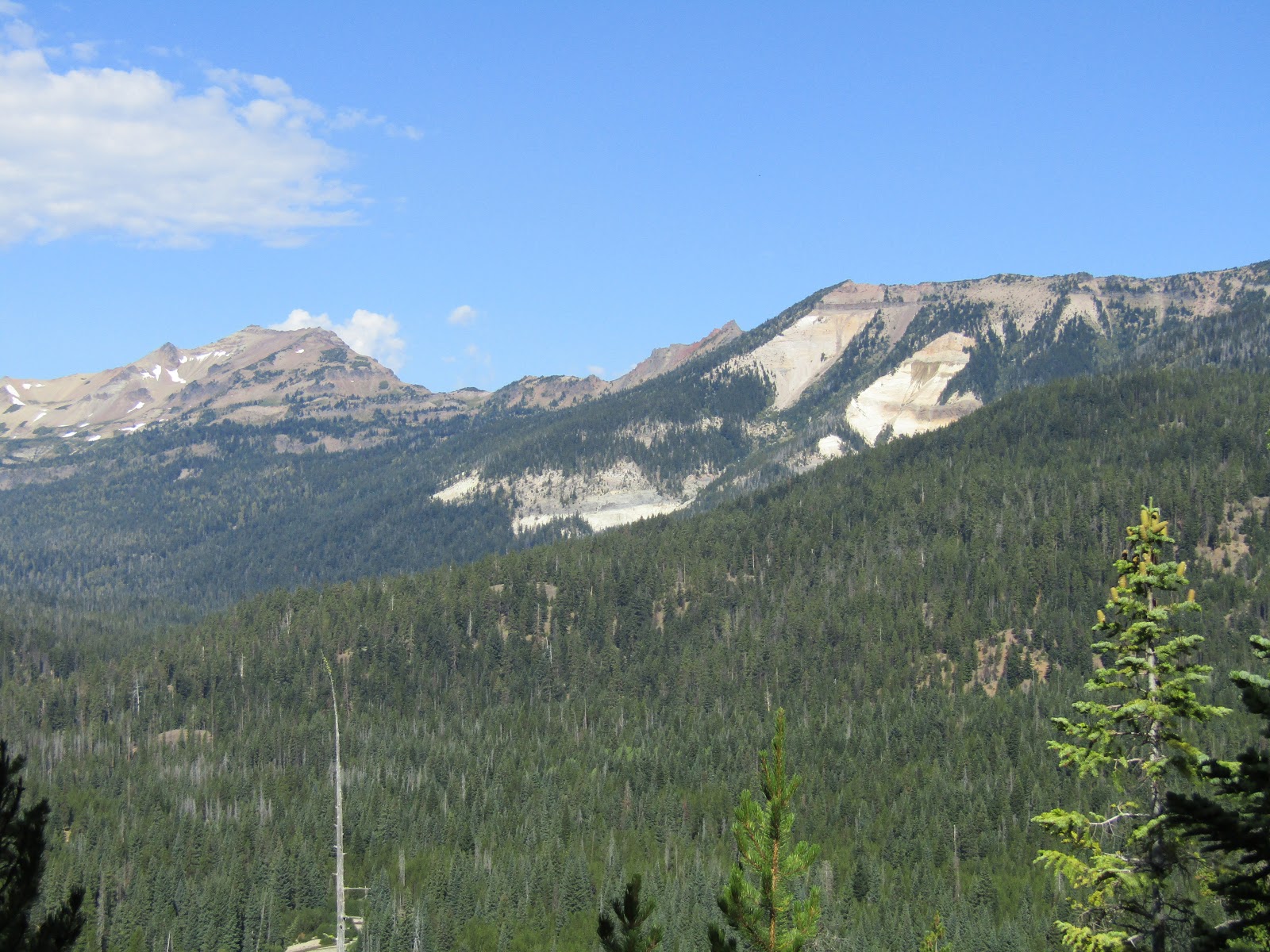
| A viewpoint on Rd. 1000. The white slash is right above camp. |
 |
| Gilbert Peak views from Rd. 1000. |
 |
| Views over to the Goat Rocks and Bear Creek Mt. from Rd. 1000. |
There is another trail up Bear Creek Mt. and a trail that runs beside the river near camp. I did not do either of them, but that means there is one or two more days of riding from Conrad Meadows.
I had to drive home in very hot weather, got held up for quite awhile by road construction, went past a bad car accident, and drove through two thunder and lightning storms. Never a dull moment!
GPS COORDINATES TO BLACK PINE
GPS COORDINATES TO CONRAD MEADOWS


Thank you so much for posting this! I love your blog and I have been waiting for you to do one on Conrad Meadows for ages, as it's one of the places close-ish to me that I have not made it to yet. Thank you again!
ReplyDeleteYou're welcome!
DeleteLoved the pictures and commentary.
ReplyDeleteThanks!
DeleteThank you , great info and beautiful pictures
ReplyDeleteIn years gone by I have been to conrad many times. Always enjoyed it. The pictures sure bring back many memories. At 80 and no horse, I do not expect to get back up there, so thanks for posting. Cliff Huff. Soap Lake Wa.
ReplyDeleteWe camped at Black Pine this last week. There were 5 other rigs during the week & as they left more came in. Great camp sights. Lots of washboard getting into it. Beautiful scenery with a variety of terrains. I highly suggest carrying a green map when riding the trails. Thanks for sharing, Holly!
ReplyDeleteForgot to mention...we rode the 40 mile loop. Started at Icicle creek...French creek then on to Meadow Camp & returned on Jack Creek Trail. Spent the night on the trail.
DeleteHolly! I was one of the three ladies :) We are so happy to see your blog, and I thought you were one tough cookie, going out on your own! So glad to see it was for sharing this amazing spot and the trails we didn't get to! Cheers to many more adventures! :)
ReplyDeleteThis comment has been removed by a blog administrator.
ReplyDeleteIs there a map of the trails? To know their length or if they loop back?
ReplyDeleteIf you want a map of either area, try Green Maps, that's what I used for Black Pine.
ReplyDeleteThis comment has been removed by a blog administrator.
ReplyDelete