Tuesday, October 17, 2023

Pederson Sno Park, Rye Spur Horse Camp and Great Meadow Sno Park, Oregon

October usually has at least one week of good weather, which makes it easy to fit in a final camping trip for the season, so I decided to do a few rides in Southern Oregon, between Medford and Klamath Falls.

Rye Spur Horse Camp

Sadly, I started having a flare up of an injury I sustained back in July, so the rides were not as long as I normally do, or as enjoyable. But I started at Pederson Sno Park on Dead Indian Memorial Road, which is a PCT trailhead. Unlike a lot of sno parks this one is quite small, parking could be tight in the summer, but it was empty while I was there. It had become drizzly and misty, so the ride south along the PCT was a little chilly. Most of this section is forested anyway, but there was one open area where I had a brief view through the fog.

On the PCT from Pederson Sno Park.

A foggy, drizzly day on the PCT.

A brief view through the fog, on the PCT.

After the ride I drove over to Fourmile Lake Road and found Rye Spur Horse Camp. There is a trailhead just off of Highway 140 with the same name, but the horse camp is on a spur road about 3.5 miles up Fourmile Lake Road. There is no signage for the camp at all, until you actually get to it, and although I had the number of the spur road, it also had no signage, so I sincerely hoped I was going the right way. Once there, it opens right up into a rock quarry type of area, complete with a pond. There is a bathroom and a set of three steel corrals, but otherwise you can just camp anywhere in the large gravel lot. There is one picnic table near the pond, some home made fire rings, cell service that comes and goes, no manure bin, and it is free to camp.

The only sign is right by the camp.

Rye Spur Horse Camp.

No one else was there, I was wondering if hunters might use it, but apparently not, and the weather cleared right up for the next couple of days.

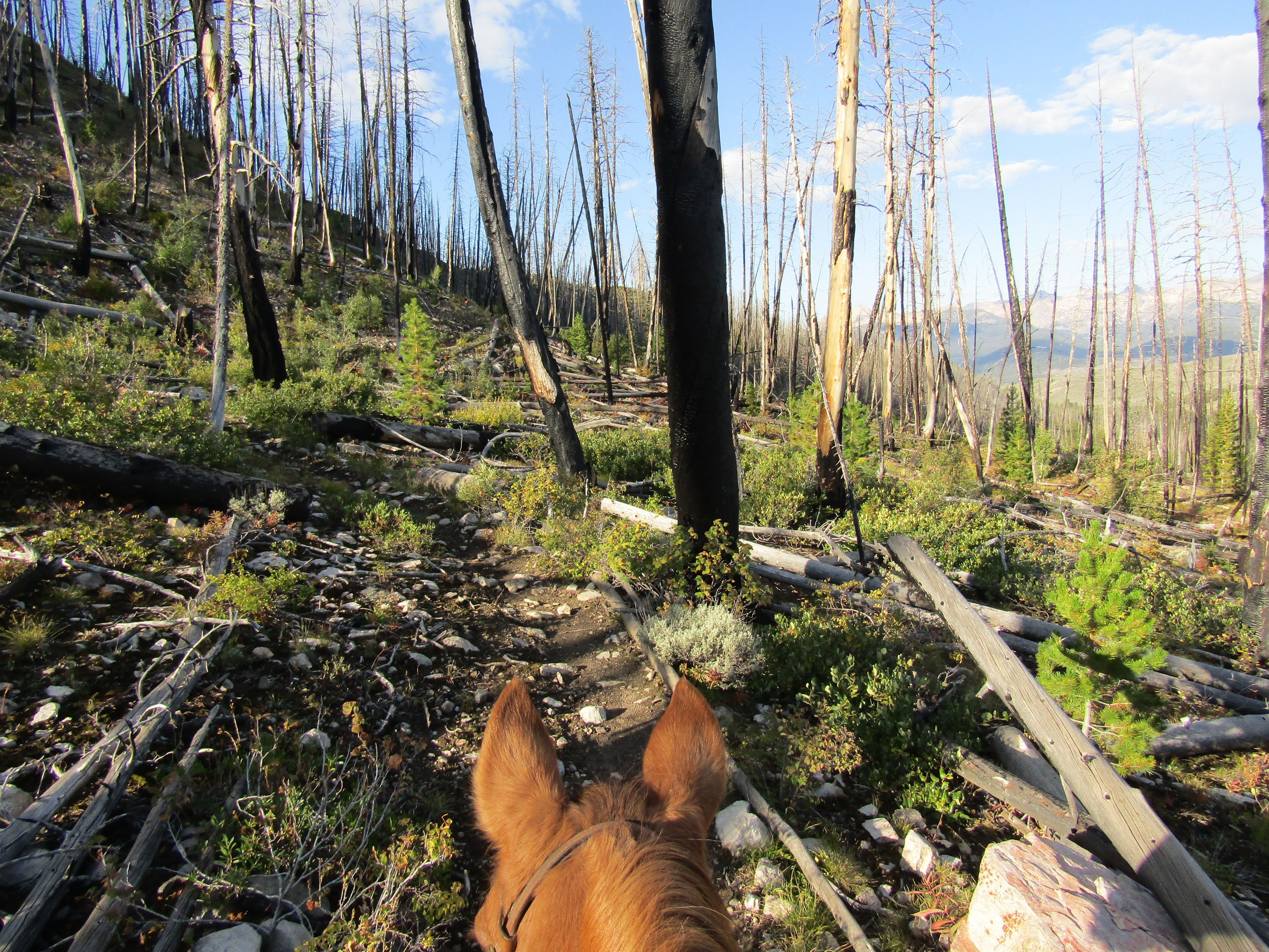
The following day I rode the Rye Spur Trail that leaves from camp. I knew it headed back down to the highway, but I found out it can be done as a loop. Not too far along, there is a nice viewpoint all way over to Klamath Lake.

Looking down onto Klamath Lake from the Rye Spur Trail.

On the Rye Spur Trail.

A great viewpoint over to Klamath Lake.

I rode to the trailhead at the highway first, then I doubled back and did the South Ridge Trail back to camp. For a lengthy stretch, this trail turns into a road, and from there I got some nice views of nearby Mt. McLaughlin.

The junction with the South Ridge Trail.

On the South Ridge Trail.

The South Ridge Trail becomes a road for awhile.

Mt. McLoughlin views.

The obvious other ride to do from this camp is over to Fourmile Lake, but because I had camped previously at Fourmile Lake Horse Camp in 2015, I did not go over there on this trip. To read about my previous trip, click here: Fourmile. Had I been feeling better I might have done it anyway, but instead, after my second night, I drove back down to Highway 140 and stopped in at Great Meadow Sno Park for my final ride.

Great Meadow.

I knew I could go up into the Mountain Lakes Wilderness from there, but since I have already ridden into that area in the past, I started following the High Lakes Trail, that skirts the meadow.

After awhile I started passing some campgrounds, that were closed for the season, and eventually made it over to Lake of the Woods. I was somewhat surprised that horses would be allowed on this trail, just because this can be a very busy spot in the summer. After riding for about two hours I got to the Brown Mt. Trailhead and suddenly there was a sign from that point on, saying no horses allowed.... AND also pointing back the way I had just come....there is no way to know this as you leave the sno park. I even passed a Lake of the Woods employee, who said nothing to me. Being a very quiet October weekday, I'm guessing nobody cared.

A coyote in Great Meadow.

On the High Lakes Trail.

Mt. McLaughlin at Lake of the Woods.

Lake of the Woods.

Lake of the Woods.

I figured that was my cue to turn around, and instead of going all the way back on the same trail, I cut across the meadow back to my truck.

Heading back across Great Meadow.

Great Meadow Sno Park.

This concluded my last trip of 2023...until next year!


GPS COORDINATES TO PEDERSON SNO PARK

GPS COORDINATES TO RYE SPUR

GPS COORDINATES TO GREAT MEADOW SNO PARK

Thursday, October 12, 2023

Boundary Creek Trailhead and Bull Trout Horse Camp, Idaho

This is the last blog, of three, about my 2023 trip into the Sawtooth's, or in this case, the White Mountains and the Boise National Forest. For part two, click here: Champion and Tin Cup

The White Clouds.

After leaving Tin Cup, I drove over to Boundary Creek. The actual trailhead is up at the end of Boundary Creek Road, but closer to the highway is a spot to park and camp, with a corral and a pasture! On Saturday while driving by, I had seen a rig there, so I was hoping they would be gone by the time I needed it, on the following Tuesday, and I lucked out.

The camping near Boundary Creek Trailhead.

The camping area is first come first serve and there is a large corral that opens up into a very large field with a stream running through it. There are quite a lot of bushes, it is not wide open, so possibly if your horse is a wanderer, there may be a chance you might not find them the next morning. It's hard to say how far they could get, but I knew my particular pony would stay put. There are no amenities at this spot and it is fairly close to the highway. There is plenty of cell service, as there is a tower on a hill across the street. Not quite a whole mile away, is the actual trailhead, with a star feeder and enough room to park and camp in the rocky turnaround, or in a nearby grassy area. There is a creek nearby, but no other amenities.

The "pasture" area.

The next day I rode the Boundary Creek Trail which climbs quite steeply to the junction with Trail 616. There are great views of the entirety of Redfish Lake on the way up, and you can also see the White Cloud Mountains.

Redfish Lake from the Boundary Creek Trail.

On the Boundary Creek Trail.

The White Cloud Mountains.

I followed 616 over to the first Casino Lake, which you just look down on from above, and then I got to another junction where I briefly started riding towards one more of the Casino Lakes. However that trail was dropping way back down in elevation, so I turned around and went over to one of the Garland Lakes instead. These particular trails are shared with motorcycles and mountain bikes, but I did not see anyone all day.

One of the Casino Lakes.

One of the Garland Lakes.

On the way back down the Boundary Creek  Trail.

After completing that ride I had to ponder for awhile what I wanted to do next, extend my trip a little longer, or wrap things up like I had originally planned. I decided to wrap things up, but I wanted to try to do a ride off of Highway 21 on the way home. I had looked at my map and picked out a specific ride to a couple of lakes, but the next day when I got to that area, there was nowhere to park a horse trailer, so I continued driving and on the fly decided to check out Bull Trout Lake instead.

As I was puttering very slowly on yet another pothole ridden dirt road I started to wonder if this had been a good choice. There were a lot of dispersed camping spots along the way and just as I was thinking maybe I should park in one of them, a sign appeared saying "horse trailer parking" and lo and behold I had stumbled onto a horse camp that I had no idea was there, since my map of the area did not include this section.

The day use area, at Bull Trout Horse Camp.

Bull Trout Horse Camp has four spots that you can fit bigger rigs into. Three of the spots are near the entrance, and then another one is situated farther away near where the camp loop road ends, in a turnaround area. The sites have corrals, and there is a bathroom, a water hand pump, and a dumpster. There is also a creek very close by. The camp is gated and locked because it is reservation only, and they do not allow anyone in there without a horse. There is a day use area with a loading ramp, which is where I parked.

One of the spots at Bull Trout Horse Camp.

The last couple of nights at Boundary Creek had gotten really cold, with ice on my windshield, and when I started my ride from Bull Trout, it was still a little chilly. But like the weather in higher elevations, things change quickly, and I would be wearing a T shirt and shorts by the afternoon.

I decided to ride the Warm Springs Trail which started out very level and passed by Martin Lake as well as another unnamed lake. Then the trail headed downhill quite steeply into Deadman Canyon, following Deadman Creek. I got to an area where there was a small meadow, at which point I decided to turn back. The plan was, I needed enough time to drive at least halfway home that same day. The Warm Springs Trail continues on, (13 miles one way) until it reaches it's other end, at the highway. This is in the Boise National Forest and these trails are also shared with motorcycles and bicycles, although yet again, I did not encounter anyone.

On the Warm Springs Trail.

Martin Lake.

Where the Warm Springs Trail starts to get steep.

A little meadow on the Warm Springs Trail.

Heading back up along Deadman Creek.

Warm Springs Creek, near the horse camp.

I left that afternoon and drove to a random spot along the highway in Oregon, that I had stayed at before, and then cruised the rest of the way back the following day. So glad I made this second trip into the Sawtooth's. Many many, beautiful rides, and if you are set up for dispersed camping, there is no shortage of that, at nearly every trailhead.


Tuesday, September 26, 2023

Champion Creek Trailhead and Tin Cup Horse Transfer Camp, Idaho

This is a continuation of my September 2023 trip into the Sawtooth's. For part one, click here: Grandjean

After leaving Grandjean, I stopped off at Little Redfish Lake because I had camped in a nice little dispersed spot there before, and it is one of the only areas with cell service. BUT when I arrived, they were doing road work in that exact area, and my spot had been obliterated, foiling my plan. So I hung out by the lake for awhile, it was a rest day, and then eventually drove over to Decker Flat instead.

Little Redfish Lake.

I had camped at Decker Flat previously as well, and it is a very nice area, although literally about 2 minutes out of cell range. The cell tower in the valley is not located very high in elevation. 
The exact spot that I was in before was available...score....so I nabbed it. Just as I arrived, a skittish looking antelope, came down to the river for a drink, and then jumped in and swam across to the other side, in record time.

Decker Flat is a large open area beside the Salmon River, and Road 310 runs through it for miles, all the way over to Redfish Lake Road. Where Rd. 310 starts, there are plenty of great dispersed spots along the river, or you could also set up further down, near an irrigation canal, either way, there is easy access for stock water. RVers tend to like to be right along the very edge of the river, but there is also plenty of room on the other side of the road. There are no amenities other than some hitching rails, which outfitters use, at the road junction, which is a good place to park in order to ride the Hell Roaring Trail, as the actual trailhead does not have trailer parking. 

An antelope swims across the Salmon River.

Directly across the highway from Decker Flat is the 4th of July Road which goes up into the White Cloud Mountains. About halfway up is the Champion Creek Trailhead which was my destination for the following day. This road is very slow going, no matter what, but it had just been graded and ended up actually being one of the better roads I encountered during the entire trip.

Champion Creek Trailhead/Camp is free and has three back-in spots, that longer rigs can fit into, plus a couple of other spots alongside the loop road. There are hitching rails, star feeders, a loading ramp, and a bathroom. But no manure bin, and unfortunately no water. There is a creek that you could access via the main road, but it is not convenient. Like all trailheads in this area, there is a map on the kiosk.

Champion Creek Trailhead.

This is a funny trail because it appears that it is going to head up into the mountains and start climbing, but it actually follows a ridge up above the road, back the way I had just driven in, which made me wonder why they put the trailhead where they did.....and then it drops back down in elevation.  

Eventually it follows Champion Creek through a very pretty valley and then I got to a meadow area, where there were some hunter's tents set up. After that, the trail was suddenly not clear anymore, which didn't make a lot of sense, since one would think that Champion Lakes would be the ultimate destination. Since the uncleared part of the trail was in a burn area, it was a little frustrating trying to get around a few sections, but I made it! The map showed another shorter way, from the opposite direction, to get in to these lakes, and when I reached them, everything was cleared again, so it was just the middle section that was a pain.

On the Champion Creek Trail.

Sawtooth views on the Champion Creek Trail.

On the Champion Creek Trail.

Lots of Aspens.

Found an antelope skull.

The first lake that I got to was actually the prettiest, then I went through a boggy area and continued on to the second lake, after which, I then had to go back out the same way.

Champion Lake.

A boggy area between the two lakes.

The second lake.

One, of two, Beaver dams in Champion Creek.

After creeping along the road back to the highway, I then drove over to my next destination, and proceeded to drive even slower, if that's possible, along the 2 or so miles of potholes to Tin Cup. Basically you just let the truck drive itself, at zero miles an hour, no gas pedal required.

When I got there I was surprised to see a major change, a grid of four steel corrals near the creek, that had not been there before.

New corrals at Tin Cup.

Tin Cup Horse Transfer Camp has two very large nice steel corrals and a variety of hitching rails at the actual trailhead. There is a bathroom, a loading ramp, and a hand pump that used to have potable water, but it no longer works. Road 365 continues on with dispersed camping areas on either side, and Rd. 363 which is directly across from the trailhead, also has a few spots, and that is where I camped. Some sites are better than others as far as access to the nearby creek, in some cases you have to drag water for quite the distance. The new grid of corrals is situated in the best area, where there is a trail that leads to the creek. They are first come first serve, and when I arrived they were being used, so I set up my portable corral elsewhere.

Sunset at Tin Cup Horse Transfer Camp.

On my last trip I had done the short loop ride that goes by Yellowbelly Lake, but I was not able to do Alice or Toxaway Lake because that year an earthquake had come through and uncleared the trails.
This time I set out in the morning not sure whether I would do them as two different rides or as a  loop instead.

Pettit Lake.

On the trail to Alice Lake.

A lot of small trees got knocked over.

I made up my mind once I got to Alice Lake, since it took way less time to get there than I had thought it would. I am very glad I did the loop, the middle part, in my opinion, is the prettiest section. I climbed up to Twin Lakes, then over Snowyside Pass, where another two unnamed lakes are nestled down below. I passed Toxaway and Farley Lakes and then since this ride is a little rocky, which slows things down, I went back along Yellowbelly, since I knew I could pick up the pace a bit on that section. This is a 21 mile loop, from the trailhead, but I added extra mileage to and from the horse camp, especially going back the longer way, and it took 9 hours.

Alice Lake.

Alice Lake

Alice Lake from above.

Twin Lakes.

Looking at a couple of unnamed lakes on the other side of Snowyside Pass.

On the other side of Snowyside Pass.

At an unnamed lake.


Toxaway Lake.

Farley Lake.

When I got back, the horse people using the corrals had left, but at 9pm at night a couple of RVers pulled in very close to me. It was dark and they probably didn't realize how many other open areas there were. In any case I was giving my horse the next day off, which was good timing, since the next morning started out stormy with some rain showers, so I moved on to my next destination.

Stay tuned for the last installment of this trip.