This is a continuation of my six week trip to Arizona: After leaving Hot Well Dunes:
I had heard about the riding in the Dragoon Mountains, but I'm not sure I was completely expecting what I found. Some really awesome rides!
 |
| Cochise Stronghold. |
Outside of the little town of Cochise, is Cochise Stronghold on Ironwood Rd. I knew that there was a dispersed camping area, but it's on a little rutted dirt side road, so I passed it the first time, then ended up turning around and going back, after the camp host explained that was indeed the loop I was looking for. There is also a large day use only trailhead, for horse trailer parking, that's close to the camping area. And lastly at the end of the road is the hiker trailhead and people campground, where no horses are allowed.
 |
| Cochise Stronghold. |
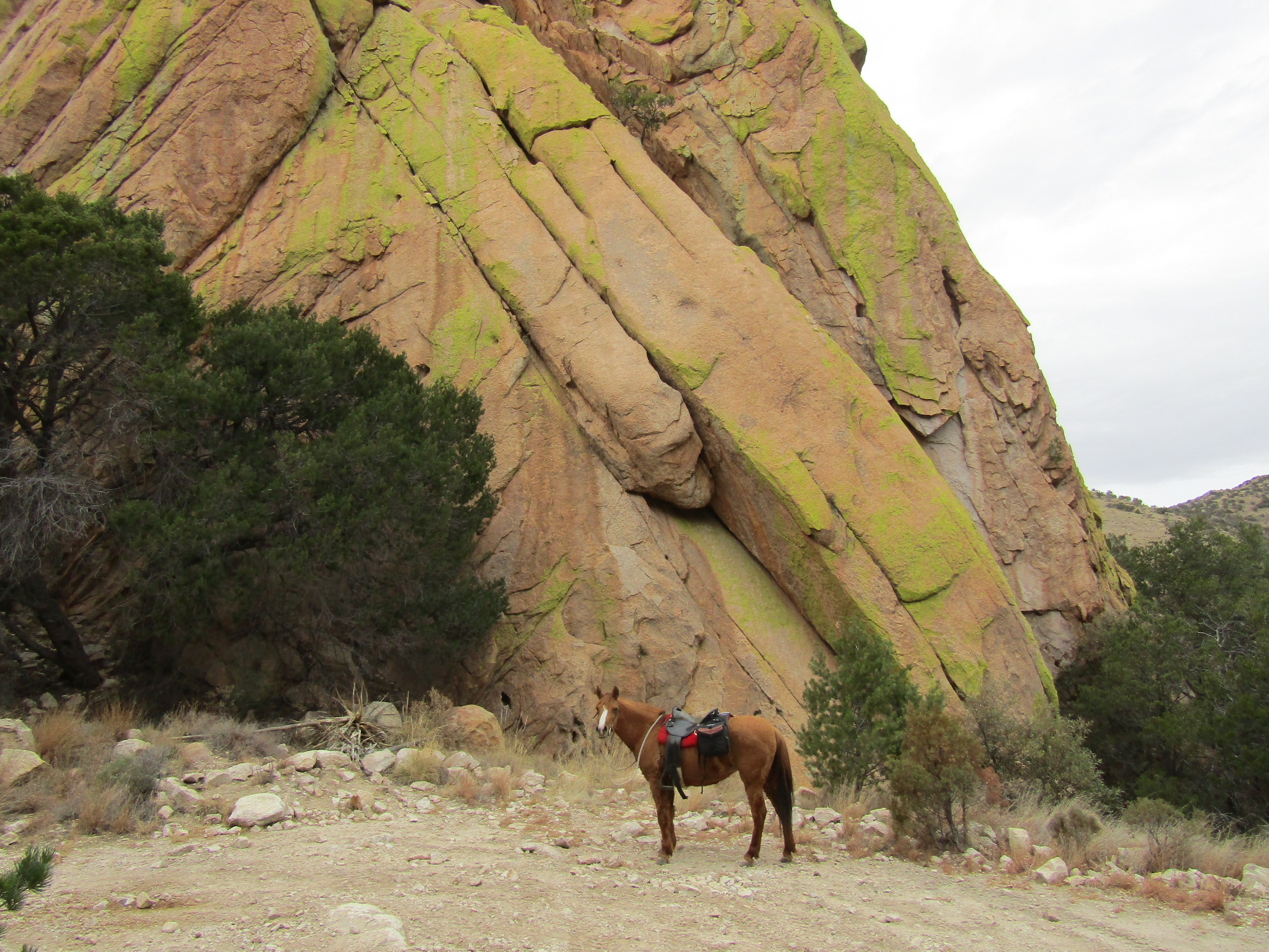
There is one very large flat spot, that works great for bigger rigs, but if that one is taken, which it was when I was there, then sometimes getting into, or finding another spot, isn't the easiest task. I squeezed myself into pretty much the only available site that was left, before the loop road becomes a lot less trailer friendly. I was glad to have gotten it, later that evening a big motorhome came in and spent at least an hour trying to maneuver their way around into a tiny spot. There are no amenities, not even a bathroom. I was told, after chatting with a young rock climber, that this area has world class granite, and the majority of the other campers were climbers. The GPS directions at the bottom of this blog will show exactly where to turn for this camping area.
 |
| My camp spot at Cochise Stronghold. |
This is a very beautiful area, and besides the obvious rock formations, it is almost tropical when compared to other parts of Arizona, with a variety of trees, grass and other foliage. A stiff wind picked up just after I arrived, that night it rained hard, and the next morning there was ice everywhere. I had to wait a pretty long time before it warmed up and I was able to ride. There is a tie trail that leaves the horse trailer parking area and meets up with the hikers trail. After that there is a junction where you can continue to follow the Cochise Indian Trail or go left on the Middlemarch Canyon Trail. I just stayed on the Cochise Trail, it climbs up and eventually gets to the Stronghold Divide which separates the east and west sections, and then drops down again to a small trailhead on the west side.
 |
| On the Cochise Trail. |
 |
| On the Cochise Trail. |
 |
| On the Cochise Trail. |
There were some other horse people that had been riding a little ways behind me the entire time, and once I reached the trailhead on the west side, I stopped, and they caught up. I chatted briefly with them, they were just riding the trail one direction, and getting picked up with a trailer. I went back the same way, making this about a 16 mile ride.
 |
| Just before I started dropping down to the west side. |
 |
| At the Stronghold Divide. |
After another frigid night, my 7th in a row, I decided to drive to the other side of the Dragoons, to Council Rocks, outside of Tombstone.
From Tombstone, I took Middlemarch Rd. which is 10 miles of washboard, to the enormous dispersed camping area by Council Rocks. I had not seen any other horse campers at any of the previous places I had been up until this point, but in this area I saw a couple of trailers. I didn't end up parking anywhere near them, this was a Sunday and most of the camping spots were taken by RVers and climbers. There are a plethora of huge areas to fit any sized rig, and road 687 goes on for miles, so I just continued driving until I found a little pull out that worked for me. There is lots of cell service, but zero amenities.
Finally some warm weather! I had started to notice a pattern, the warmest weather always seemed to happen on the days when I was not actually riding.
 |
| My camp spot at Council Rocks. |
The next day my first ride was along a pretty well used horse trail at the base of the rocks, which took me into Slavin Gulch. This is kind of a "find your own way" type of area, there are a lot of little side trails, so sometimes I would veer off on one of those, but usually find it to end up not being particularly horse friendly. Once I ran out of trails, I followed a road and found myself back at the same west trailhead that I had ridden to from Cochise.
 |
| Council Rocks. |
 |
| Almost back to the west trailhead. |
 |
| Council Rocks. |
For my second ride, I started at the base of the rocks again, but this time going the other direction to the south. I came across another pretty big climbers area, but after that the trail petered out, so I bush wacked for awhile with my goal being to reach China Camp Rd. which I could see from afar. Unfortunately trying to cut cross country over to the road proved a little tricky, I was coming up against fence lines without gates. At one point I came across a nice rancher. He couldn't quite figure out where I had come from, since I just appeared suddenly out of the foliage, but he let me ride through his cow corral and out his gate, whereupon he locked the gate after me.
 |
| Heading towards a popular climbing area. |
China Camp Road is narrow and rocky and meant for 4x4's, not cars. Once it gets up above and beyond the rocks, there are many other side roads, and by roads I mean rustic tracks, some that are very steep, that meander all over the place. There are ALOT of old mine shafts and tunnels in this area from the abandoned San Juan Mine. The view is apparently fantastic from atop China Peak, but I had ridden quite a few hours already before getting to this area, so I didn't continue the entire way. I saw some other horse people coming down from the peak, and when they got to where I was, a lady said " we meet again". Turns out she was one of the same people I had seen before over at Cochise Trail, but this time she had different riders with her. They expressed concern about my horse, she was very sweaty, with a very fuzzy winter coat, and I had just taken her down a very steep short cut trail, not actually intended for a horse, that had been cut into the side of a hill.
I reassured them that she was fine, and that we were just taking a break. They left and eventually I caught up with them and passed them, my horse having gotten her second wind. They had parked at the beginning of the road, but I still had to ride all the way back to camp, making this a 7 hour day.
 |
| At the saddle on China Camp Rd. |
 |
| Abandoned mines were everywhere. |
 |
| My turn around spot on the way up China Peak. |
In case anyone is wondering, since this area is outside of Tombstone, yes, you can stop into the town of Tombstone, ride down the dirt road and pretend you are back in the wild west. I had no desire to do that, but I have been there before, and it is pretty interesting to check out the history of the place.
 |
| Tombstone, early enough in the day, before the mobs of tourists arrive. |
 |
| The Boothill Graveyard in Tombstone. |
It was time for me to move on once again. I had very little water left, but I had planned my trip so that in between all of the dry camping areas, I was also going to be stopping and riding at places that had water. Luckily my horse is not a big drinker, and I could go for some pretty long stretches without having to worry about it.
Next stop: Empire Ranch and Apache Springs.
To be continued....
GPS COORDINATES TO COCHISE STRONGHOLD
GPS COORDINATES TO COUNCIL ROCKS


How would you ratethe trails you ride on for difficulty and the scary factor? Are they dog friendly?
ReplyDeleteWhich trails? I'm probably the wrong person to ask that! I ride in places others won't go. I found Arizona trails to be easy, just depends where you are, an occasional trail might have a rocky section. I don't have a dog, but as long as you carry water, I don't see any issue.
ReplyDeleteThis comment has been removed by a blog administrator.
ReplyDelete