There are two ways to get to the destination of Lookout Mt., the shorter more scenic way which I will start with, or the longer less scenic way.
 |
| On top of Lookout Mt. |
To get there: From Prineville, drive 15 miles east on Hwy 26. Take a right at the sign for Walton Lake and Big Summit Prairie. Follow this road for 14 miles, stay to the right where it becomes road 42 ignoring the left turn towards Walton Lake. Watch for the sign for Independent Mine and Round Mt. There is a washed out dirt road that heads uphill, drive up it very briefly and take a left into the large parking area. This road continues on to the official trailhead for hikers and passenger cars but it is not suitable for trailers. If you really don't want to drive up the short 100 yard stretch of it, there is also a paved pullout on the side of road 42. This is also where you park to do the Round Mt. trail.
 |
| The large parking area for trailers. |
 |
| Lookout Mt. TH sign at trailer parking area. |
Leave the parking area following the trail towards Independent Mine, this climbs uphill for awhile until it meets a dirt road, the trail does continue across the road but it is just as easy to stay left on this road for a few minutes until you reach a large gravel circle.
From here the trail continues on the other side of the circle, and it is marked with a stick inside of a cairn.
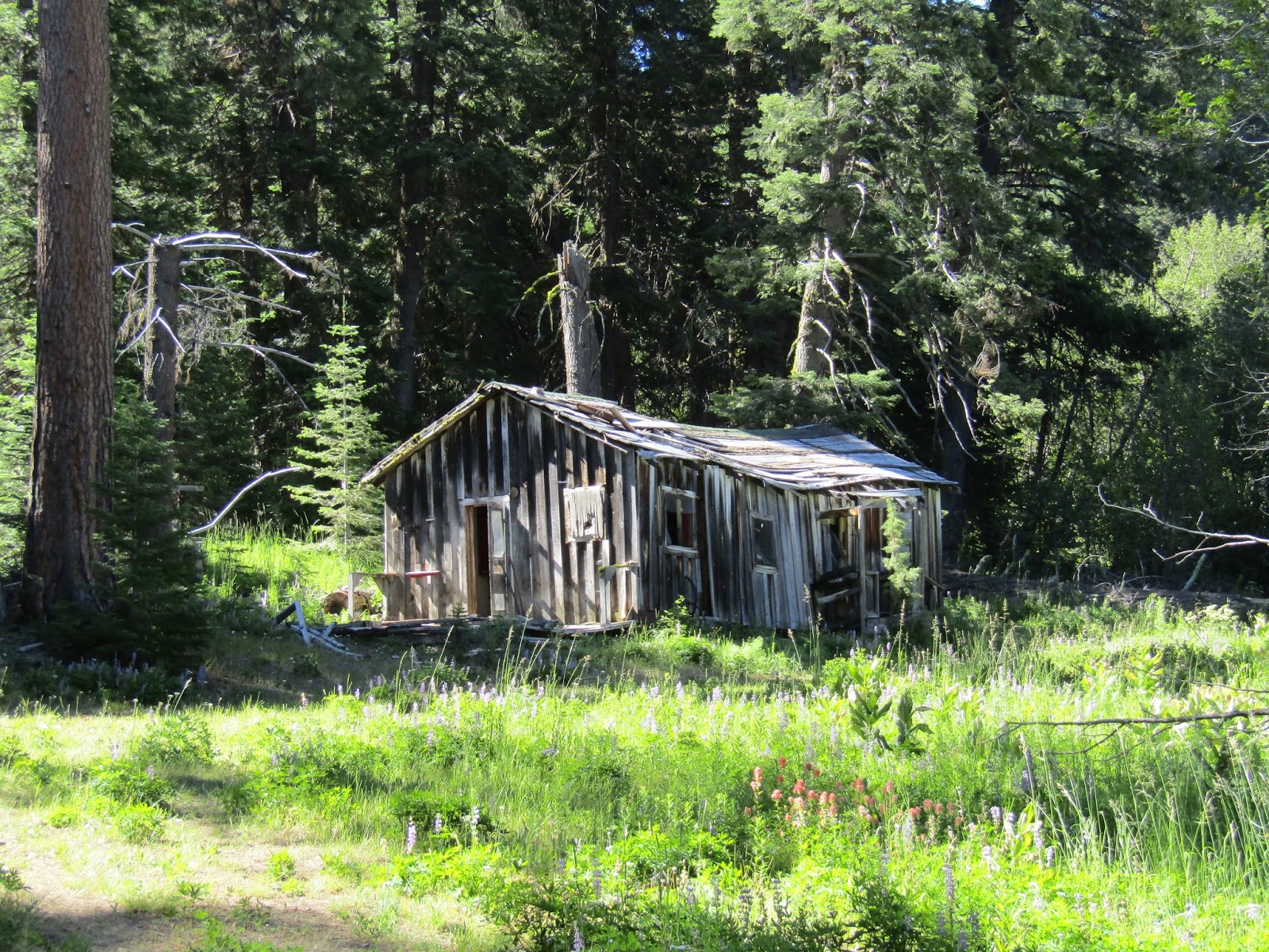
However for a fun detour stay on the road briefly until you get to the sign for the Baneberry Nature Trail. Follow this, bypassing the actual nature trail, and you will find yourself among a collection of old buildings that was once the Independent Mine.
 |
| The trail continues across this gravel area, but it is worth a detour to the mine first. |
It's getting more overgrown than it used to be, but the buildings are still accessible. It is also possible to do the short nature interpretive trail as well. There are informational plaques and benches along the way as you loop around.
 |
| On the way to Independent Mine. |
 |
| One of the old buildings of the Independent Mine. |
After exploring this area head back to where the trail leaves the gravel circle and continue on uphill.
After coming out into an open area, the official parking lot/trailhead for cars is off to the left. As of this writing there are no signs to point the way anymore, but there is a pole on the ground next to a trail heading that way... or if you miss that, the next junction has the pole still intact, but no sign... take a left there.
You will now be at the Mother Lode TH.
From here follow the Independent Mine Trail, which is trail 808 and is the start of the loop. There are several junctions and a lot of different trail names with a few having been changed in the last few years, but it is less complicated than it might seem. It's basically just a loop with another trail down the middle of it, which is a short cut. As you head uphill the trail goes through a lush flower filled area with several small streams meandering across the trail here and there.
Then it opens up with views of Round Mt. and also way down to Big Summit Prairie.
 |
| On the Independent Mine Trail. |
 |
| Round Mt. |
 |
| On the Independent Mine trail....always lots of corn lilies. |
Eventually there is a junction with a trail going to the left called the Line Butte Trail. Just for fun and because I like a longer ride I often do this detour, it adds a few miles to the trip. It heads out over to what is called South Point. This trail doesn't get a lot of use, but it is cleared and eventually after passing through what was once an old fence line it more or less disappears. But there are some great views from here down onto the Paulina area and way over towards where Mud Springs Horse Camp is.
 |
| Views from South Point. |
 |
| Views from South Point. |
Back on the original trail you will be just a short ride away from the top of Lookout Mountain with fantastic views as far as the eye can see.
 |
| On the top of Lookout Mt. |
 |
| On the top of Lookout Mt. |
To continue the loop from here follow trail 808 pointing towards the snow shelter. (the trail to the left is the other way I mentioned to arrive on top of Lookout and if you go down it by mistake you will be a long way from your truck!)
Fairly soon there will be a short side trail to the right that leads to the shelter if you want to check it out, otherwise continue downhill until you reach the next junction. Take a left here if you want a more scenic, less steep route back down. The trail to the right which is 808 A is a mile shorter and does get you back to the same place, but it's not as fun and you will miss the second mine.
 |
| Views of Big Summit Prairie. |
 |
| The junction, left is more scenic and less steep. |
After switch backing downhill you will come to the Mother Lode Mine which is a three story building on a hill to the right. Apparently all this mining was for cinnabar which is where they get mercury from. They shut down the mines in the 50's and the buildings have been rotting away ever since.
 |
| The Mother Lode mine. |
 |
| On the Lookout Mt. Trail. |
Just shortly after passing the mine you will recognize, (hopefully!) that this is the trail you originally rode up on before taking the left to the parking area, so at this point just retrace your steps back to your truck.
This is a 10 mile ride if you do it without taking the detour onto the Line Butte Trail.
The other longer way to do this trail is from what was once the old Ochoco Ranger station.
To get there: From Prineville, drive 15 miles east on Hwy 26. Take a right at the sign for Walton Lake and Big Summit Prairie. Follow this road for 8 miles and the old Ochoco Ranger station will be on the left. It is just a paved parking area with a bathroom, you can park there, or at a pullout beside the road at the actual TH which is just up the road on the right.
 |
| The start of the 15 mile trail from the Ochoco Ranger station. |
 |
| Ochoco Ranger Station parking area. |
This is a 15 mile out and back, and other than arriving at the top of Lookout Mountain the rest of this ride is completely different. At one point don't be surprised if you happen upon an enormous herd of sheep with several sheepdogs that will likely bark at you. You will climb steadily uphill until reaching North Point and then the top of the mountain and the junction with the other loop trail.
 |
| Sheep on the Lookout Mt. trail. |
 |
| Looking out from North Point. |
Happy Trails!!
GPS COORDINATES TO THE INDEPENDENT MINE TH
Really I am very impressed with this post. Just awesome, I haven’t any word to appreciate this post bullwhips.
ReplyDelete