I've been meaning to check out these two camps for awhile and yet it just didn't happen..... until now! They are both in the same general area in the Mt. Hood National Forest near Parkdale Oregon.
 |
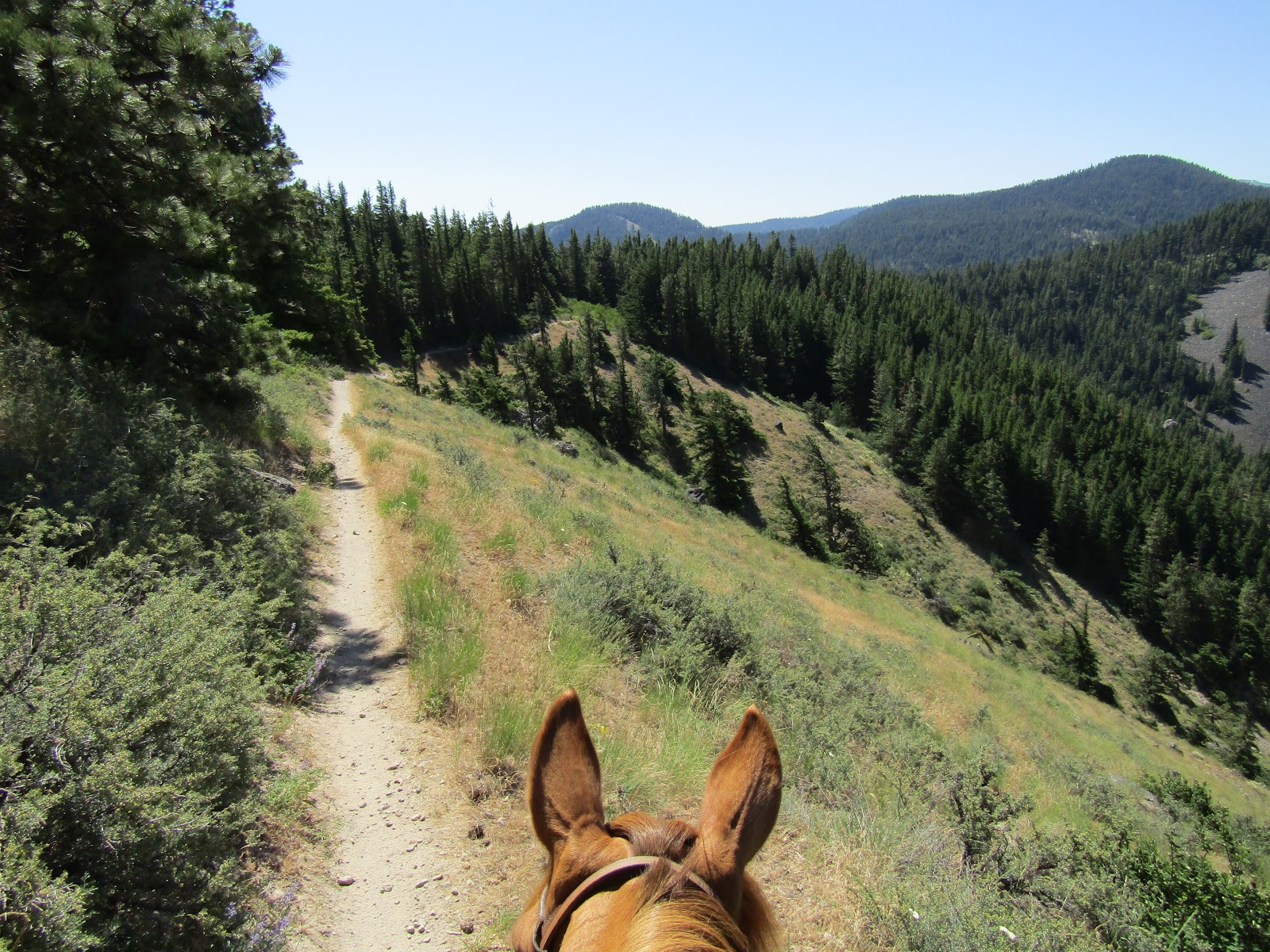
| Mt. Hood from the Surveyor's Ridge Trail. |
I decided to visit Gibson first, and as I pulled in to camp a man on a horse rode over to say hi and mentioned that he and his wife were clearing trails.
As I was tacking up, his wife came by, we chatted for awhile, and she gave me the lowdown on the trails in the area. Back Country Horsemen adopted this little camp several years ago, so it would not be closed down, and Barb and Dave are volunteers.
Gibson Prairie is a cute and cozy camp with three sites that all have four horse log corrals. There is a bathroom, a manure bin with a wheelbarrow, picnic tables and fire rings, and stock water from a spring fed water trough, although you do have to take a 250 yard stroll with your horse to get to it. One of the sites will easily accommodate a large rig and another can as well, if you back in and unhook. No garbage, no potable water and no fee!
 |
| Gibson Prairie Horse Camp. |
 |
| Gibson Prairie Horse Camp. |
 |
| Spring fed water trough at Gibson Prairie Horse Camp. |
The main trail that I was aware of before arriving is the Surveyor's Ridge Trail, which is also shared with bikes, but it turns out there are also a variety of "horse/hiker only" trail loops, so on my first ride I went ahead and explored some of those. There is a map on the message board at camp and I took a picture of it with my phone and headed out.
I rode about 5.5 hours just following the various trails, and I was enjoying them quite a bit. I am more of a "wide open spaces with views" type of girl, but these trails were prettier than the average forest type of riding, with meadows here and there and plenty of wildflowers.
I did find the map a little confusing at first, but it was still helpful to plan routes, and after awhile I found it easier to get the lay of the land. Most of the trails are marked in some way, and they often go from a trail to a gravel road for awhile and then back onto a trail, so keeping an eye out for flagging or markers was the key.
 |
| On one of the horse loops. |
 |
| A meadow where the trail was a little faint. |
 |
| Lots of wildflowers. |
 |
| A lot of the junctions were signed. |
That evening I talked a bit more to Barb and Dave, it's always fun to talk to others who have camped a lot and ask about where they have enjoyed riding. I have a list of so many places to see, luckily there is no shortage of options to choose from.
The next day I started out on the Surveyor's Ridge Trail, which is 16.4 miles one way so I was obviously not going to get it all ridden in one day. To get to it, there is a tie trail just a short ways back up the main road from camp, I went ahead and flagged it, as well as another trail from camp, with neon green tape, so both are now easier to spot.
I headed south and was treated to a number of great views of Mt. Hood. I did see several groups of cyclists as the day progressed and my horse and I were certainly on the alert for them as we traveled.
Eventually the trail turned into a two track and kept going, I followed it quite a bit longer but at this point the views were gone and I was ready to turn around. On the way back for a change of scenery, I got off the trail, and took the road back instead.
 |
| On the Surveyor's Ridge Trail. |
 |
| Shellrock Mt. and Mt. Hood on the Surveyor's Ridge Trail. |
 |
| On the Surveyor's Ridge Trail. |
Barb and Dave had left that day, so I had the evening to myself, my activity was primarily gorging on as many wild strawberries as I could get my hands on.
My original plan had been to ride two days at Gibson and then two days at Knebal but that changed when I realized how much more riding there was at Gibson, so the next day I got back onto the Surveyor's Ridge Trail and headed north. This ended up being a quiet day on the trail, with no cyclists at all. I rode as far as Bald Butte, with more views of Mt. Hood, Mt. Adams, Mt. St. Helens and Mt. Rainier along the way, as well as a birds eye view down onto Parkdale. The trail does continue a little farther but I wanted to go back and check out the rest of the horse/hiker trails. After pretty much checking out every nook and cranny of the remaining trails, I went back to camp and then drove on over to Knebal which is a mere 7.5 miles away.
 |
| Mt. Hood from the Surveyor's Ridge Trail. |
 |
| Bald Butte on the Surveyor's Ridge Trail. |
 |
| On the Roller Coaster Trail ( so named by Dave) |
Knebal Springs has 7 sites, but only 3 of them have corrals. Non horse people can camp here as well, and indeed they do, it seemed like it could be a pretty busy place. There is a bathroom, a spring fed water trough, a waste water dump, picnic tables and fires rings, but no manure bin, ( I dispersed mine into the forest) no potable water and no garbage. It is $12.00 per night to camp there.
When I arrived on Thursday in the late afternoon, there was just one nice older non horse couple there, but later on a few more people showed up.
 |
| Knebal Springs camp spot #5. |
There were some very friendly deer hanging around camp, one in particular would walk right up to me, getting within just a few feet to check me out. I bring salt and mineral blocks with me for my horse and it wasn't too long before one of the deer found them. I wasn't particularly bothered by them helping themselves to my salt, but much later that night after dark there was a loud knocking noise that went on and on. At first I thought it was someone in camp, but finally I had to go outside and investigate. It was a deer trying to get at the salt blocks from the outside of the corral and banging on the plastic container I keep them in. I ruined her fun, removing the salt which spent the night in the trailer instead, and I ended up with a much more peaceful night's sleep.
 |
| She found my salt and went to town on it. |
The Knebal Springs Trail, which is shared with cyclists, leaves from camp and if you combine it with the Bottle Prairie Trail you can make a 9 mile loop. I rode it clockwise, eventually getting to a nice side trail up to Perry Point, with some views east over to the Columbia Plateau, and then later in a clear cut area, as I was almost back to camp, there were a few glimpses of Mt. Hood. This loop is pretty much the extent of the trail system, but in order to get a little more riding mileage, there is the option of following a trail that leaves the loop and makes it's way over towards Lookout Mt.
 |
| On the Knebal Springs Trail. |
 |
| Mt. Adams from the Knebal Springs Trail. |
 |
| On top of Perry Point. |
 |
| On the Knebal Springs Trail. |
After my ride the camp was really starting to fill up, so I got the heck out of there to free up my spot for someone else. Obviously doing these two camps in one trip is a great option, but if there is only time for one, Gibson has the most riding, less crowds, and has been lovingly tended to by volunteers such as Barb and Dave and has all the main amenities you could want... so check it out! All the trails are cleared and ready to ride!
GPS COORDINATES TO GIBSON PRAIRIE
GPS COORDINATES TO KNEBAL SPRINGS


Just wanted to make sure people who read your post keep an eye out for Aslan, the dog missing in that area.
ReplyDeleteContact bringing home Aslan on Facebook if you see him.