Tuesday, September 26, 2023

Champion Creek Trailhead and Tin Cup Horse Transfer Camp, Idaho

This is a continuation of my September 2023 trip into the Sawtooth's. For part one, click here: Grandjean

After leaving Grandjean, I stopped off at Little Redfish Lake because I had camped in a nice little dispersed spot there before, and it is one of the only areas with cell service. BUT when I arrived, they were doing road work in that exact area, and my spot had been obliterated, foiling my plan. So I hung out by the lake for awhile, it was a rest day, and then eventually drove over to Decker Flat instead.

Little Redfish Lake.

I had camped at Decker Flat previously as well, and it is a very nice area, although literally about 2 minutes out of cell range. The cell tower in the valley is not located very high in elevation. 
The exact spot that I was in before was available...score....so I nabbed it. Just as I arrived, a skittish looking antelope, came down to the river for a drink, and then jumped in and swam across to the other side, in record time.

Decker Flat is a large open area beside the Salmon River, and Road 310 runs through it for miles, all the way over to Redfish Lake Road. Where Rd. 310 starts, there are plenty of great dispersed spots along the river, or you could also set up further down, near an irrigation canal, either way, there is easy access for stock water. RVers tend to like to be right along the very edge of the river, but there is also plenty of room on the other side of the road. There are no amenities other than some hitching rails, which outfitters use, at the road junction, which is a good place to park in order to ride the Hell Roaring Trail, as the actual trailhead does not have trailer parking. 

An antelope swims across the Salmon River.

Directly across the highway from Decker Flat is the 4th of July Road which goes up into the White Cloud Mountains. About halfway up is the Champion Creek Trailhead which was my destination for the following day. This road is very slow going, no matter what, but it had just been graded and ended up actually being one of the better roads I encountered during the entire trip.

Champion Creek Trailhead/Camp is free and has three back-in spots, that longer rigs can fit into, plus a couple of other spots alongside the loop road. There are hitching rails, star feeders, a loading ramp, and a bathroom. But no manure bin, and unfortunately no water. There is a creek that you could access via the main road, but it is not convenient. Like all trailheads in this area, there is a map on the kiosk.

Champion Creek Trailhead.

This is a funny trail because it appears that it is going to head up into the mountains and start climbing, but it actually follows a ridge up above the road, back the way I had just driven in, which made me wonder why they put the trailhead where they did.....and then it drops back down in elevation.  

Eventually it follows Champion Creek through a very pretty valley and then I got to a meadow area, where there were some hunter's tents set up. After that, the trail was suddenly not clear anymore, which didn't make a lot of sense, since one would think that Champion Lakes would be the ultimate destination. Since the uncleared part of the trail was in a burn area, it was a little frustrating trying to get around a few sections, but I made it! The map showed another shorter way, from the opposite direction, to get in to these lakes, and when I reached them, everything was cleared again, so it was just the middle section that was a pain.

On the Champion Creek Trail.

Sawtooth views on the Champion Creek Trail.

On the Champion Creek Trail.

Lots of Aspens.

Found an antelope skull.

The first lake that I got to was actually the prettiest, then I went through a boggy area and continued on to the second lake, after which, I then had to go back out the same way.

Champion Lake.

A boggy area between the two lakes.

The second lake.

One, of two, Beaver dams in Champion Creek.

After creeping along the road back to the highway, I then drove over to my next destination, and proceeded to drive even slower, if that's possible, along the 2 or so miles of potholes to Tin Cup. Basically you just let the truck drive itself, at zero miles an hour, no gas pedal required.

When I got there I was surprised to see a major change, a grid of four steel corrals near the creek, that had not been there before.

New corrals at Tin Cup.

Tin Cup Horse Transfer Camp has two very large nice steel corrals and a variety of hitching rails at the actual trailhead. There is a bathroom, a loading ramp, and a hand pump that used to have potable water, but it no longer works. Road 365 continues on with dispersed camping areas on either side, and Rd. 363 which is directly across from the trailhead, also has a few spots, and that is where I camped. Some sites are better than others as far as access to the nearby creek, in some cases you have to drag water for quite the distance. The new grid of corrals is situated in the best area, where there is a trail that leads to the creek. They are first come first serve, and when I arrived they were being used, so I set up my portable corral elsewhere.

Sunset at Tin Cup Horse Transfer Camp.

On my last trip I had done the short loop ride that goes by Yellowbelly Lake, but I was not able to do Alice or Toxaway Lake because that year an earthquake had come through and uncleared the trails.
This time I set out in the morning not sure whether I would do them as two different rides or as a  loop instead.

Pettit Lake.

On the trail to Alice Lake.

A lot of small trees got knocked over.

I made up my mind once I got to Alice Lake, since it took way less time to get there than I had thought it would. I am very glad I did the loop, the middle part, in my opinion, is the prettiest section. I climbed up to Twin Lakes, then over Snowyside Pass, where another two unnamed lakes are nestled down below. I passed Toxaway and Farley Lakes and then since this ride is a little rocky, which slows things down, I went back along Yellowbelly, since I knew I could pick up the pace a bit on that section. This is a 21 mile loop, from the trailhead, but I added extra mileage to and from the horse camp, especially going back the longer way, and it took 9 hours.

Alice Lake.

Alice Lake

Alice Lake from above.

Twin Lakes.

Looking at a couple of unnamed lakes on the other side of Snowyside Pass.

On the other side of Snowyside Pass.

At an unnamed lake.


Toxaway Lake.

Farley Lake.

When I got back, the horse people using the corrals had left, but at 9pm at night a couple of RVers pulled in very close to me. It was dark and they probably didn't realize how many other open areas there were. In any case I was giving my horse the next day off, which was good timing, since the next morning started out stormy with some rain showers, so I moved on to my next destination.

Stay tuned for the last installment of this trip.


Tuesday, September 19, 2023

Grandjean Horse Camp, The Sawtooth's, Idaho

In 2020 I went to the Sawtooth's for the first time, and after doing eight rides, I knew I would have to return, since there were still at least that many more rides left for me to do. On this second trip I started at Grandjean Horse Camp which is on the west side of the mountain range. To read about the first visit into the Sawtooth's, click here: Tin Cup, Redfish, Iron Creek

Baron Lake.

Sadly, after driving all day, once I got to the dirt road that leads to camp, the 7 or so miles of constant potholes slowed me right down. I remembered this about my previous trip, the riding is beautiful, but the roads are horrendous. Finally I pulled in and realized that finding a good spot was going to be tricky. No one was camped there, but the only spot I thought I could get into and be somewhat level, was right near the backpackers parking area. So I got myself situated by the horse trailhead instead, with my corral set up in site #30. More about that later....

When I walked down the camp road to the pay station, it said, "pick a spot and the host will contact you." It was late and so I settled in and went to bed.

Grandjean Horse Camp.

Grandjean has 8 spots with hitching rails, on a separate road from the nearby people campground. This is not a great camp for bigger rigs, some of the spots are long enough, but maneuvering around with a lot of trees in the way can be tricky. It is not a one way road though, so driving in from either direction is possible in order to fit into a site. There are two bathrooms, a stock water trough, that is hidden in the trees, ( I didn't even notice it until the next morning ), and a potable water spigot, that you cannot attach a hose to, in the backpackers parking area. There is a dumpster and recycling container, but no manure bin. I have an old book about the area, and the description said there were corrals. What this refers to is some corrals, out of sight, up above the camp, next to an old guard station, but you cannot get a rig up there, and you can't use those corrals anyway. This is a first come, first serve camp and it is $20 a night. There is absolutely no cell service.

The mapboard at Grandjean Horse Camp.

In the morning since I was dealing with an hour time difference, it seemed I needed to get moving quickly, and I knew the rides in this area were going to be long. I started on the S. Fork Payette River Trail which meanders though a valley and then climbs gradually to Elk Lake and beyond. I turned back when I came across a walkway over a boggy area which was completely falling apart. I might have been able to cross it, or go around somehow, but although I had a map, and the trailhead also had a map, nothing had mileage on it, so I had no idea how much further it was to the lake.

One of the creek crossings on the S. Fork Payette River Trail.

On the S. Fork Payette River Trail.

A nice mini waterfall.

Where I turned around.

Heading back down the S. Fork Payette River Trail.

That evening as I was perusing my map and trying to decide if I was going to do two or three days of riding, a guy drove in, who turned out to be the camp host. He immediately asked me why I was camped there, and not in the horse camp. As I mentioned before, I was near the trailhead, and my corral was set up in a spot right behind my trailer. There was no way I could have fit into the actual parking area for that spot. What I shortly learned from the camp host was that where I was parked, by mere feet, was actually considered the trailhead, where you can leave a rig, in order to pack in, but you aren't supposed to actually camp there. He asked if I would move. We had a little chat about it, and he said he realized that there was no way to know that you can't camp there, no signage, nothing, so he said he would let it slide this time. I also didn't know yet how long I was going to stay, but he said as long as I was just there for a few days, it would be fine. Apparently people have camped at the trailhead on purpose, instead of in the sites, because they think they can get away without paying, but that was not my intention.

The following day I got an early start, to ride the approximately 20 mile out and back to Baron Lakes along the Baron Creek Trail. Obviously this trail, as well as everything else in the area, can be done as a loop instead, if you are packing in. The trail starts out easy and then has a switchback section climbing up to the lakes.

On the Baron Creek Trail.

I passed Baron Falls and then eventually there are three lakes, the lower one is not in sight, but the trail goes right past the middle one, the largest lake, which is where I stopped. This took 9 hours to complete, with a few short breaks.

Starting to climb, on the Baron Creek Trail.

On the Baron Creek Trail.

Baron Falls.

At Baron Lake.

At Baron Lake.

On the way back down the Baron Creek Trail.

On the way back down the Baron Creek Trail.

On the last day I rode the Trail Creek Trail which is shorter, about 12 miles, but steeper, with several creek crossings, one of which is a little "interesting". The camp host had mentioned that he had not heard of a horse actually going on the side trail up to the lakes, and he warned me about a boggy section. Once you leave the main trail and start the climb, it does become much steeper with boulder sections. The boggy stuff was actually not a problem, but it could be worse earlier in the season. Just like Baron, there is more than one lake, but I just went to the lower one. This is in a burned area, and any non designated side trails tended to not be cleared.

On the Trail Creeks Trail.

Some very pretty rock, in the creek.

On the Trail Creeks Trail.

Trail  Creek Lake.

Trail Creek Lake.

That evening the camp host came back over to see me, he seemed a little perturbed, since he had assumed I was leaving that day. I said no, but I would be gone the next day. He asked me a bunch more questions and it seemed clear that even though I had wanted to go over to the hot springs in the morning, when the outside temperature was cooler, he wanted me to be out of there pretty early. So much for my relaxing day off from riding....

 At that point it was 6pm so I gathered my stuff and I walked over to the river where Sacajawea Hot Springs are. They are not really close to the horse camp, just over a mile and a half, one way, but I was determined to have enough time to enjoy them, and then get back by dark. People have made rock lined pools to catch the scalding hot water that flows out of the side of a hill and mixes with the river water. I chatted with a girl who was also there solo, but it wasn't super busy even on a Friday night. Also there are quite a few different pools, and they are separated along the river, so you can find your own little spot.

One of the pools at Sacajawea Hot Springs.

As I was walking back, the camp host happened to be driving by, and asked if I wanted a ride. I took him up on it, which was only a little awkward, since by this time our interactions were slightly strained. I do understand his point of view, he thought he was doing me a favor by not making me move, but he was definitely stressed out about it the whole time. Hopefully the forest service will add some signs at some point, also if someone does camp in one of the actual spots, and then packs in for several days, it's a bit of a mystery on how you would be charged for that. Maybe just for the nights you spend in the actual camp, not the nights out on the trail. Not everybody can just arrive and leave to pack in on the same day, especially if they live out of the area.

The next morning as I was driving out, someone in a car ahead of me was stopped along the road. I pulled over to see what was happening and a guy told me that there was a truck hanging off the side of the hill. I could see a small tree had been bent, and the truck was caught precariously on it, looking like it could roll down the embankment, but it had not, which was quite lucky. The people that had stopped were in a tizzy because they thought someone might still be in the vehicle. The windows were tinted but I could see footprints where someone had climbed out, and that the airbag was deployed, but nobody was in the drivers seat. I continued on my way, and a short while later a tow truck passed me, so that took care of that. I was actually amazed that a tow truck would come all the way out there on a gravel road, because in Oregon they will not drive off pavement.

This is just the first blog of three, so stay tuned for the next leg of the journey.

GPS COORDINATES TO GRANDJEAN


Sunday, August 27, 2023

White Pass and Sand Flats Horse Camps, Washington

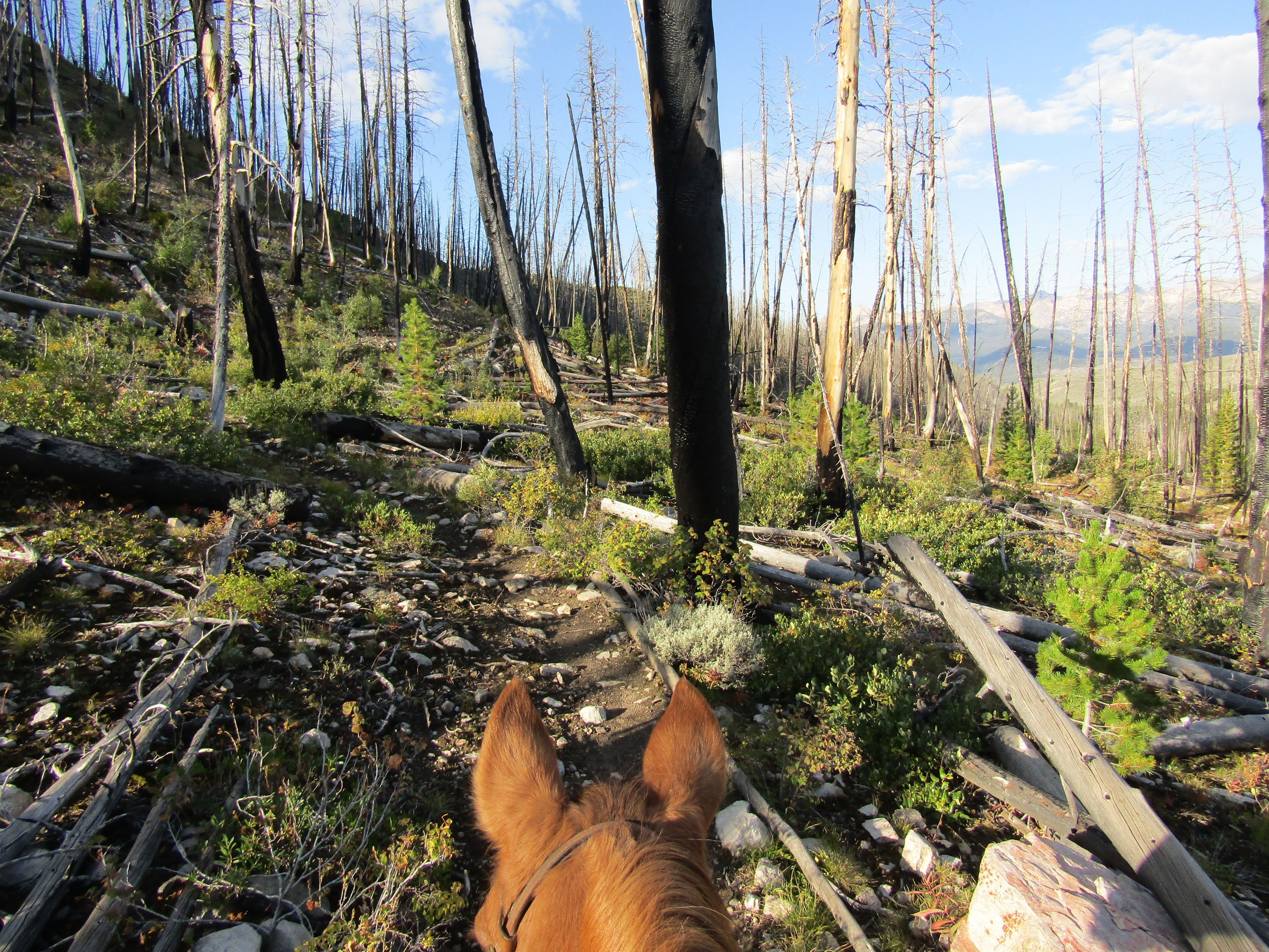
I had to take about three weeks off from riding, due to an injury, so me and my pony were both chomping at the bit, to get back out camping. White Pass and Sand Flats, with all their beautiful scenery, were just what the doctor ordered.

On the PCT near White Pass.

Driving still bothers my injury (riding does not, luckily) but I had to do a fairly long drive in order to get out of the wildfire smoke back at home, so when I arrived at White Pass, I was extremely delighted to finally exit the truck. I was the only horse person camped there the first two nights.

If you are heading west, White Pass Horse Camp is to the right just off Hwy 12, a 1/4 of a mile before you get to the summit and ski hill. There is a campground/trailhead sign and a horse riding sign, but nothing on the highway that actually says horse camp. Once you get to the camp/PCT trailhead, which is shaped a bit like a lopsided figure eight, there is a pretty wide open area, and then an additional camp loop. The loop is nice and shaded, but it is closer to the highway. The sites are not numbered, but there are 6 in the loop and then an additional 12 if you count the open area with all of the hitching rails and little pullouts. It seems to me that the camp was configured differently in the past. Several of the extra spots are not as nice, and it's obvious that no one uses them. There is a bathroom and you can find stock water from a nearby creek, however it's too far to haul it back to camp. There is no manure bin, and it is free with a NW Forest Pass. Bigger rigs can fit into the open area, but might have a tougher time squeezing into the loop spots. There is great cell service, at least with Verizon.

My spot, a pull through, still partially in the open area.

White Pass Horse Camp.

Leech Lake is close by, with a people campground that has an additional two bathrooms, and there are two dumpsters in a parking area near the lake. The PCT runs right through the horse camp so hikers tend to make frequent pit stops at the bathroom, and sometimes set up their tent and spend the night. Maybe it is not always like this, but the bathroom was not stocked with toilet paper and there were no new permits to fill out at both of the northern trailheads.

Leech Lake, and White Pass Ski Hill.

The first ride was to the north on the PCT, which was nicely cleared, but I did see a few ground hornet nests ( my horse did not get stung). Then I looped around via Dumbbell Lake, Cramer Lake Trail and Dark Meadow Trail. The shortcut trail past Dumbbell Lake was clear, but after that Cramer was only partially cleared. I found out later that evening, when a guy drove through camp and stopped to talk to me, that he had done the clearing, but was not able to cut the larger trees, with the size of saw that he was carrying. Everything was fairly easy to negotiate other than a very large tree right on the cliffy section of Cramer Lake Trail, at which point I had to dismount and my horse and I had to climb straight up a steep hill with loose dirt, and back down, Man From Snowy River style, to get around it.

On the PCT, heading north.

At Dumbbell Lake.

Cramer Lake.

On the Cramer Lake Trail looking over towards Dog Lake.

The William O Douglas Wilderness sign.

On the second day, I rode the PCT to the south. After crossing the highway, I was only riding for a few minutes when I came across a big downed tree, which continued to be the theme for quite some time. Eventually after climbing uphill for quite awhile, you get to the scenery, and it is worth it! The PCT runs across an open side hill for awhile, the trail is decent, but hikers do have to step off of it, in order for a horse to pass. Shoe Lake is the obvious destination for a day ride, but I rode a little bit further past it first, just to get some more views of my beloved Goat Rocks. I've always loved that area since I first visited it about 10 years ago.

Mt. Rainier.

On the PCT in the Goat Rocks Wilderness.

On the PCT.

On the PCT, heading south.

Looking down onto Clear and Rimrock Lakes.

The Goat Rocks.

Then I backtracked and rode cross country down to Shoe Lake. There is an actual trail that goes to the other side of the lake from the PCT, and so I rode it back up, after spending about 45 minutes chilling out down below.

Shoe Lake is stunning.

Down at Shoe Lake.

On the way back I decided to quit dodging hikers on the PCT, and more importantly, I didn't feel like going around all the downed trees again, so I followed the Chairlift Trail over to White Pass Ski Hill and rode down from there instead. Once you reach the highway you can cross it, ride through the lodge parking lot and then get onto the trail beside Leech Lake, but I decided to just ride the 1/4 of a mile along the highway instead. Since there is a very wide pullout lane I wasn't particularly close to the traffic.

On White Pass Ski Hill.

On White Pass Ski Hill, looking at the lodge and Leech Lake.

That evening I got company! Three different horse campers set up shop in the loop, and at one point or another, I met and talked with them all, exchanging info about the state of the trails.

The following day I left and drove over to Sand Flats Horse Camp. This entailed driving on a paved but bumpy road through Mt. Rainier National Park, as well as getting stuck behind a very slow moving road striping truck, all on the steepest part of the downslope, and making sure not to mow down some cyclists, having no room to move over because of a plethora of traffic coming the other way. Consequently it took an hour and a half to drive just over 40 miles.

When I arrived there were two rigs there that looked like day riders, and another rig with a couple of ladies who had just gotten back from packing in. They were parked in the one spot with shade, but they mentioned they were leaving soon, in case I wanted their site. I had found a level area by then, so I stayed where I was, but I did chat with them briefly and took a picture of a map they had of the trails. When they heard where I was from, they mentioned that I had just missed a fellow rider from my home turf, whom I have met a couple of times.

Sand Flats Horse Camp.

The one shaded spot at Sand Flats Horse Camp.

Sand Flats is a small camp, if there a lot of people there you would have a harder time maneuvering with a bigger rig. There are four sets of highline poles and some hitching rails, but you can camp wherever you feel like it. The aforementioned shady spot is the only one with a picnic table and official fire ring. There is a bathroom, a bear proof garbage receptacle and a spring fed stock water tank that is located where everyone can easily get to it, as well as water from a creek. There is no manure bin, no cell service in camp, but you get it once you ride uphill just a little ways, and it is free to camp with a NW Forest Pass.

Sand Flats Horse Camp.

The centrally located water trough at Sand Flats Horse Camp.

After the two ladies left I had the place to myself until the owners of the two other rigs rode back into camp. One of them also left, but Becca and Tracy with the Tahoma Back Country Horsemen, spent the night.
I knew the riding in this area was more suitable for a seasoned horse, but Tracy proceeded to introduce himself, and then launched into a couple of horror stories about mishaps he had had riding on the trails, including a friend's horse who had died falling off the specific switchbacks that I was planning to ride the following day. The funny thing was, once I got onto the switchbacks, I was wondering what all the fuss was about, especially once I rode some sections of the nearby PCT, which were much more sketchy. 

I always let my pony roam loose in horse camps to graze, if possible, and Becca and Tracy decided to let their critters out too, although with hobbles. With the water trough in the middle, we just treated the camp as a large pasture, and everyone was happy!

From Sand Flats, you could do one big loop leaving from one side of camp and returning on the other side, but I wanted to do two long rides, and I wanted the extra time for detours, so I left on the Norse Peak Trail the next morning.

On the Norse Peak Trail.

Looking at Crystal Mt. Ski Hill.

It didn't take long to reach Goat Lake. The day before, Becca and Tracy had just installed a second hitching rail above the lake. From there I followed the newly made horse route around a wash out and eventually reached the PCT. I headed north briefly, to check out Crow Basin, and then turned back south until I reached a junction, at which point I took a detour down to Basin Lake.

The junction for Goat Lake.

The new hitching rail put in by BCH.

Goat Lake.

On the PCT.

At the junction to Basin Lake.

Basin Lake.

After hanging out at Basin Lake, which is a great place to pack in to, I went back up to the PCT and continued south to Norse Peak. My plan was to drop back down through Bullion Basin. I hadn't reached the actual junction to Bullion yet, but I came across a trail going down into it, and so I took that. This turned out to be the quicker but much steeper way down. From there, the Bullion Basin Trail continues dropping in elevation until it reaches a service road, which I rode all the way back to camp. 

On the PCT by Norse Peak.

Looking down into Bullion Basin.

Down in Bullion Basin.

If you follow the bridge across the creek from camp, the Northway Trail heads up the mountain on the other side. It was the weekend and I had heard that cyclists use that trail, so I thought maybe I would skip that section. Instead, for my second ride, I started out on the fairly boring service road again, over to the Silver Creek Trail which climbs back up in elevation, somewhat steeply, and passes several lakes.

An old mine with some fake skeletons in it, on the Silver Creek Trail.

On the Silver Creek Trail.

A fly fisherman at Henskin Lake.

At Upper Henskin Lake.

From the lakes I continued on the Crystal Mt.Trail to the top of the ski hill where they have a gondola that takes hikers, bikers and tourists up to the top, and they can wander around and enjoy the view of Mt. Rainier, or hike back down. Some of them seemed a little unprepared for hiking back down, carrying nothing with them, and wearing inappropriate footwear. This is definitely where I started to see quite a few more people and when I got to the top, of course, all the people were delighted to see a horse. One group of Asians mentioned they had never seen a horse before in person, (how is that possible?) and so I told them they could pet and take photos of my pony. The short way back to camp from the top would be to take the Northway Trail, but instead I retraced my steps back down to the lakes and then took an uncleared trail straight up to the PCT. I rode south briefly from there heading towards Chinook Pass, but turned back at one of the only sections that I could actually turn around on, since the trail is cliffy in this area, and went back north until I got to the junction of the Bullion Basin Trail.

Mt. Rainier, from atop Crystal Mt.

A tourist volunteered to take my photo atop Crystal Mt.

The gondola on Crystal Mt.

Heading back down the Crystal Mt. Trail.

On the PCT, heading back north.

Becca and Tracy had already left the day before, and another non horse couple with an RV were gone by the time I got back, so the camp was deserted that night.

This is definitely a gorgeous area to ride, but you need to be experienced, have a steady horse and you cannot be afraid of heights. There are some very narrow sections of the PCT, with steep drop offs that have eroded, and your horse has to be careful about where they put their feet. When you are at some of those sections, often there is no way to turn around, so you have no choice but to keep going. Having said that you could also do shorter rides, like up to Goat Lake and back, or into Bullion Basin and back, and skip the PCT all together.