Friday, August 27, 2021

Wallowa Lake Trailhead and McCully Trailhead, Eagle Cap Wilderness, Oregon

Fires, fires everywhere....I was going to go to Washington but as soon as I had completely solidified that plan, a fire started in the exact area I was heading, so I decided to go to Eastern Oregon instead, back into the Eagle Cap Wilderness. I can always count on trails being cleared there, and the air quality looked good, so I got ahold of the Joseph Rodeo Grounds and arranged to spend four nights there.

On the East Fork Wallowa River Trail.

When I called ahead I didn't actually speak to anyone on the phone, and no one ever returned my call, but someone answered an email I sent, and gave me very basic information. The funny thing was, she mentioned I should enter via Alder Rd. because it has easier access for a horse trailer, and she gave me a gate code. So I drove in that way, unlocked the gate, looked across to the other entrance on Wallowa Ave. and immediately noticed that that gate was wide open, and stays that way all the time, with plenty of room to swing a trailer in! 

The rodeo grounds are pretty small, and it was nice and quiet there. It's only $10 per night, per horse, and there are large pens, with water, and it's within walking distance of downtown, with access to restaurants etc.
There is a camp host guy that stays there, and a self pay box mounted on a pole, although I had to ask the guy where it was, since there is no information posted anywhere about overnight stays. The bathrooms are locked, when there are no events going on, but there were about nine porta potties set up when I arrived. However when I returned from my ride the next day, they had all vanished into thin air, and never did reappear, so I would not rely on there being bathroom access.

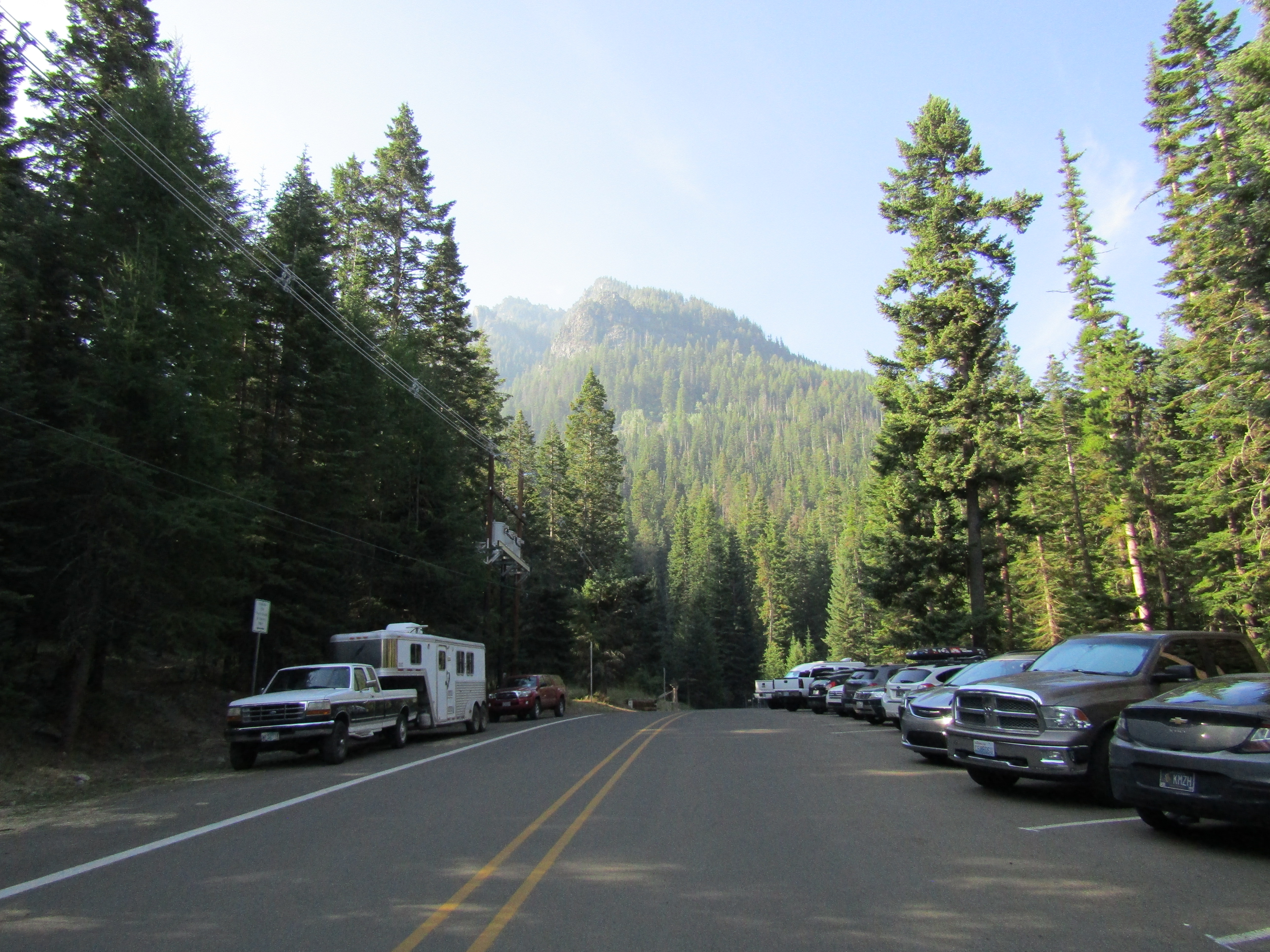
The first two rides I wanted to do were from the Wallowa Lake Trailhead which can be pretty busy, it's close to the lake, resort, and campground areas which are always teeming with tourists, and unlike most trailheads in the Wallowa's it doesn't have the best situation for camping. I had been there many years before on a hiking trip and figured I wouldn't want to stay there, which is why I went to the rodeo grounds instead.
But if you do want to camp at the trailhead, the parking is alongside the road, on a hill, and you can highline or tie to hitching rails. There is a bathroom across the road, in a picnic area. To add to the ambiance, there is also a power station right nearby that makes a loud humming noise constantly. 

Wallowa Lake Trailhead.

I decided to do Ice Lake first. Once you leave the trailhead there is a choice of either the East Fork Wallowa River Trail or the West Fork Wallowa River Trail and Ice Lake is on a side trail off of the West Fork.

On the West Fork Wallowa Trail.

Just after the junction, there is a creek crossing which is not for inexperienced horses, and then the trail climbs up and up and up, with numerous switchbacks until you reach the lake, which is stunning. This ride is 15 miles with 3300 feet elevation gain. Your horse does need to be in shape, but there aren't any big drop offs, and the switchbacks are pretty easy, although there are rocky sections.

On the trail to Ice Lake.

On the trail to Ice Lake.

Waterfalls along Adam Creek on the trail to Ice Lake.

On the trail to Ice Lake.

Once I got there, and saw how big the lake was, and that there were only a few people around, I found a nice little private spot, stripped down to my knickers, and hopped in the lake. Very refreshing!

On the western end of the lake is The Matterhorn, a mountain that looks like it has snow on it, but it is actually white marble.

Ice Lake.

The Matterhorn at Ice Lake.

Views on the way back down from Ice Lake.

The following day I drove back over to the same trailhead, but this time I rode The East Fork Wallowa River Trail to Aneroid Lake, and a little beyond, to Camp Halton.
This is a 12 mile ride with 3000 feet elevation gain, but it's a more gradual climb than Ice Lake. On the way you will encounter a waterfall, a hydroelectric dam, a few meadows, and Roger Lake.

On the East Fork Wallowa Trail.

Wallowa Lake views from the East Fork Wallowa Trail.

The hydroelectric dam on the East Fork Wallowa Trail.

A meadow on the East Fork Wallowa Trail.

This is one of the trails I had hiked in the past, but back then, once I had gotten to the lake, I turned around and went back, without even realizing the cabins at Camp Halton were there. So this time I rode past the lake to the outskirts of the camp, left my horse behind, and walked in to see the area. Right away I met the caretaker, and he said I could wander around all I wanted. This is private property and the cute cabins are the remnants of a silver mine. Outfitters take people in to look at the place, so there is a highline system set up, but you aren't allowed to ride right through the actual cabin area. 

One of the cabins at Camp Halton.

One of the cabins at Camp Halton.

The view from the cabins at Camp Halton.

After strolling around for awhile, I collected my horse and went back over to Aneroid Lake, hung out and had lunch. Again there were very few people around, but this time I did not go for a dip.

Aneroid Lake.

That evening I walked through Joseph for awhile, which is a cute little touristy town.

It was hot, just in general, and being in Joseph instead of at a higher elevation trailhead, meant it did not really cool off that much at night. Plus there were ALOT of flies at the rodeo grounds, but despite all of that I still liked it there, and had planned to stay all four nights. However, it got smoky on the third night, and in the morning it was even smokier, so I abandoned ship, and drove over to McCully Trailhead instead.

This trailhead is about 10 miles from Joseph, but there are no signs on the way up, so I stopped at a crossroads, just to make sure I was going the right way. Unfortunately I was parked on a hill, with the whole weight of the trailer pulling on the truck, which caused me to get stuck in park. Oops. I tried numerous times to get it into gear, but it wasn't budging, so I hiked up a nearby hill to get cell service, called my trusty mechanic ( his free advice has saved my ass a few times ) and got some tips to try, including just forcing it, if I could. When I got back to the trailer a guy was walking his dog on the road and I told him he needed to get behind the trailer and push it forward a couple of  inches. He said "maybe in my younger years ". I was kidding, of course, but that was one thing that might have worked. Instead I was finally able to get it unstuck, (maybe it just needed a moment?!) and I continued up to the trailhead. Note to self: put the emergency brake on first, if on a hill, before putting it in park, not the other way around.

McCully Trailhead.

McCully Trailhead is a loop with no actual camping spots, but you can park and either tie to the various hitching rails or put up your own corral. There is a bathroom and a loading ramp and it is free if you have a NW Forest Pass, or $5.00 per day if you don't, and you can pay right at the trailhead. There is a nearby creek, but it is across the road, and down a very steep embankment, so it is not a good source for stock water. I didn't have much in the way of cell service, it came and went, but texts came through reliably.

McCully Trailhead.

It was a lot less smoky, when I arrived which was nice, but it was still drifting through the valley as I started the ride. This trail and trailhead do not get a lot of use, presumably because there is not a lake as a destination. My hiking book stated that I would likely see no one while out there, and that was true, even on a Friday. The trail climbed steadily, staying near the creek, and then it started to open up, with some mountain ringed meadows in the McCully Basin area. 

On the McCully Basin Trail.

My hiking book also mentioned that once I got to where the trail became a lot steeper, I could either keep going for awhile towards McCully Pass or if I was adventurous, which clearly I am, I could bush whack across a ridge, and I would find a large meadow. So that is what I did. There is not even a user trail into there, and it was unmolested by humans, just a lot of signs of elk and/or other critters that have spent time bedded down in this beautiful area. I could have happily done the same, with plenty of grass and water for my horse, it was tempting to stay up higher, away from the smoke.

One of the meadows in McCully Basin.

The first large meadow in McCully Basin.

Instead I eventually left my little Shangri La and continued riding until I reached about 8500 feet, where the trail becomes pretty faint and climbs steeply up to the pass. I hung out up there for awhile, and as I was looking back down towards the trailhead, the smoke cloud was very evident. I did about 12 or 13 miles that day with approximately 2400 feet elevation gain, but this trail is less rocky, and I could move out a lot quicker.

Continuing towards McCully Pass.

Nearly at the top of McCully Pass. The smoke cloud was evident down below.

Heading back down the McCully Basin Trail.

That night unfortunately the smoke stuck around, and the next day it was even thicker. My original plan had been to go to another trailhead nearby, and do one more ride, but I couldn't even see the mountains I had ridden into the day before. So I drove back down, to where I had cell service, and looked up the air quality in other areas. I had a couple of ideas in mind of places I could stop on the way back. But once I had passed all of the options, and had also gotten to the top of Cabbage Hill, and STILL there was no clear air, I gave up, and realized I would have to cut the trip short, and continue all the way back home.
The last time I was in this exact area of the Eagle Cap, I was chased out early by thunderstorms, this time by smoke. All that means, is that I need to go back again!


Saturday, July 17, 2021

North Crater Trailhead, Oregon

It's hard to find somewhere to camp in early July that is not mosquito infested, has cleared trails, and with no snow in the higher elevations. Usually ( although not this time ) the PCT is a good bet for being clear, and I know I can get at least two rides accomplished, riding both north and south. I decided to check out North Crater Trailhead, near Diamond Lake in Southern Oregon.

Mt. Thielsen from the PCT. (Pacific Crest Trail)

North Crater Trailhead has a narrow loop drive with a couple of camp sites tucked back in the trees. There are no actual parking spots for the camping, you just park in the lot. There is a bathroom, which was not stocked, some hitching rails and a loading ramp, but no water or other amenities. You can highline or put up a corral, and it is free. 

North Crater Trailhead.

North Crater Trailhead.

My camp spot at North Crater Trailhead.

This is not too far of a drive from my home, so I left early and did my first ride when I arrived. Besides the PCT there is also the North Crater Trail, which is supposed to head over to Diamond Lake. Not anymore. It is not cleared, hasn't been for awhile, and doesn't look like it ever will be, judging from the state of the junction where you are supposed to be able to do a loop. They are not allowing snowmobiles in the area anymore, and all of the old roads are a mess. I would not normally spend too much time on a trail in that bad of shape, but I persevered for quite awhile, due to the fact that I had nowhere else to ride that day. Eventually I turned back and went a different direction, ending up on Summit Rock Trail which is actually a road. I followed it until I reached Summit Rock, which has a nice viewpoint.

Just an example of North Crater Trail.

The junction where the loop used to be.

On top of Summit Rock, with a view of Mt. Thielsen.

More views to the south from Summit Rock.

On top of Summit Rock.

There was a fire burning to the north, and another fire that I could see while on top of the rock, burning to the south, but it wasn't smoky right in the middle, where I was, until later that evening when it drifted into camp for awhile.

The next day I rode the PCT to the north which I knew would take me into the Mt. Thielsen Wilderness and although I have been there before, riding from the Howlock Mt. Trailhead, this was a much more scenic way to view Mt. Thielsen. I rode all the way to Thielsen Creek ( about 16 miles round trip ) and along the way I got views of the mountain from three different sides. Unfortunately the PCT had not been cleared either, but it was at least doable that direction, and it was a nice shady gradual uphill climb with lots of opportunities to pick up the pace.

On the PCT heading north.

On the PCT looking at Mt. Thielsen.

Mt. Bailey and Diamond Lake views.

On the PCT on the west side of Mt. Thielsen.

On the PCT.

At Thielsen Creek.

Mt. Thielsen view from Thielsen Creek.

A deer grazing at Thielsen Creek.

On the last day I rode the PCT to the south, at least I attempted to. Immediately after the trail crosses Highway 138, it enters Crater Lake National Park. I knew I would not actually be riding anywhere near the lake, but I was hoping for some kind of view at some point. Mostly it was just trees, trees and more trees, and after awhile I gave up and went back, since there were just too many downed logs across the trail. There were also a few mosquito's which were irritating my horse. I ended up going back over to Summit Rock Trail/Road again and started riding towards Diamond Lake, but this was not interesting either and it was getting hot and smokier the closer I got to the lake, so I called it a day. 

On the PCT going south, too many downed trees.

On Summit Rock Trail, which is a road.

Went I got back to camp there was a family who had decided to have a picnic lunch on my picnic table directly in my camp spot. That was a first. They were nice enough people.... but who does that??? It was only slightly awkward as I untacked my horse right next to them, and put her away while they finished up. Not to mention there was another empty picnic table in the other spot, I'm guessing they must not have even seen it. After they left, I got packed up and drove on home, I wished there had been somewhere else I could have ridden in that area, but I was out of options, especially with the fires burning.


GPS COORDINATES TO N. CRATER TH


Wednesday, June 9, 2021

Moss Meadow Horse Camp, Oregon

The Fremont Winema Trail in SE Oregon is over 150 miles long and has quite a few horse camps along the way. I have camped and /or ridden at a few of them, but I had not checked out Moss Meadow, over by Paisley, until now. It is a lovely camp, that gets very little use, and I ended up having thousands of acres of national forest all to myself. In the four days I was there I actually thought it was a possibility that I would  not see any other humans at all, but the spell was eventually broken, when I saw a lone vehicle drive by on the road.

On the Fremont Winema Trail.

Moss Meadow has four spots, three of which are for medium sized rigs, and one that can fit a much larger rig. The spots are all back- in, nicely graveled and have steel corrals. There is a bathroom, (might need to bring your own TP) a loading ramp, and there is stock water just up the trail in a trough, however it is pretty stagnant, a spring is supposed to keep it flowing, but is no longer doing so. Moss Creek is nearby and although it did have a small trickle upstream, it was dried up closer to camp. There is no garbage or manure bin, and no fee, this camp is free! There is a cell tower on a nearby hill, and I had great service the entire time.

Spots are not numbered at Moss Meadow.

Moss Meadow Horse Camp.

My first ride was on the Fremont Winema Trail, heading north. There is a mile or so to ride on an old marked logging road, which leaves camp and leads to the main trail, or you can ride up Rd. 5310 to Moss Pass. I knew some trail clearing and camp maintenance had been done last summer, and sure enough the few trees that needed to be cleared were taken care of. After that I was riding along a ridge with great views. This is a pretty unpopulated part of Oregon, and it is vast. The trail starts on the west side of the ridge but eventually goes over Round Pass, so you get views over to the east side as well.

At the junction with the Fremont Winema Trail.

Allium, I think?

On the Fremont Winema Trail, riding north.

Endless views on the Fremont Winema Trail.

On the Fremont Winema Trail.

Zoomed in, from the ridge, way down onto the Chewaucan River.

This trail is geared towards horseback riders, besides the fact that there are signs at all junctions, there are stock water sources along the way, all of which actually had water, and "scenic vista" signs pointing towards even more great views. Occasional posts are missing signs, but I learned quickly just to look around for whatever it used to indicate, and I would find a side trail going to a pond, or water trough.

Found this water source just after going over Round Pass.

Eventually after riding for several hours I got to the burned part of the forest, a fire had gone through there last summer. Sometimes it is hard to for me not to keep on riding and riding, to see what is around the next bend, but once I hit the burn, this gave me an excuse to turn back.

On the east side of Round Pass.

Funky cloud and shadow.

Looking out towards Lakeview.

Turned around once I got to the recent burn.

A seasonal stock water pond.

I rode for seven hours that day, then the following day I did another seven hours, heading to the south this time. The trail actually drops downhill gradually, so by the time I turned back, I was on the valley floor. This is grazing land and I saw cows here and there, usually near creeks or meadows.
At one point there is a brief section of trail that goes through a privately owned piece of land that the owners have allowed access to, as part of the packstock route.

We dropped down off this ridge.

On the Fremont Winema Trail, heading south.

A meadow with cows grazing.

The trail enters private land briefly.

Originally I was going to head over to another nearby camp on this same trip, but I was loving my time at Moss Meadow, and so I decided to save the other camp for another time and continue exploring.

My last ride was along forest service road 5310, which the camp is on, over Moss Pass, and then downhill all the way to the Chewaucan River. The forest service website is extremely outdated (it says there are no corrals at the camp) and also that riding to the river was "about 5 miles". Just looking at it from the ridge, I could see it was more than five miles! It turned out to be just over 7.5 miles one way, although on the way back I took a shortcut along 113, a very faint old dirt road, which was a nice way to make a loop.

On Rd. 5310, almost to the river.

When I got to the river I noticed some horses grazing nearby, a QH stallion with four mares and three foals. It took them awhile to notice me, but once they did, they were very surprised. Part of the property along the river is privately owned, although there are no visible buildings, so these horses belong to someone, but they acted wild. The stud couldn't seem to believe his eyes, they must not get a lot of visitors, and he spent a lot of time snorting at us. I took my horse down to the water for a drink, and I could still hear him snorting away, even though he couldn't see us anymore. 

On the bridge over the Chewaucan River.

The mares and foals.

The stud, giving us the eye.

Hanging out at the Chewaucan River.

Views back to the ridge I had already ridden on.

On the way back I followed another dirt road alongside Ben Young Creek, and it took me to an old homestead. At first I just saw a dilapidated barn, but then tucked back in the trees was a newer cabin structure. It may be newer, but very rustic, and I realized nobody was living in it. After that I cut cross country to road 113 and looped back to camp. This is fairly open land, so it is easy to bush whack and make your own way around.

The old dilapidated barn.

A very rustic cabin.

I thought about staying one more night, but I was close enough to home to do the drive back that evening, after my ride. For anyone else who likes solitude and lots of mileage, this might be a camp to check out, I really enjoyed my time there!