Monday, June 25, 2018

Sevenmile Horse Camp, Oregon

Sevenmile Horse Camp's claim to fame is access to the historic Santiam Wagon Road which runs from the Albany area to Sisters. This link shows all the different sections, and has info about the history:  Santiam Wagon Road

Lush greenery on the Santiam Wagon Road.

To get there: From Sweet Home, travel 32 miles east on Hwy 20, just after mile marker 59 look for the sign for Sevenmile Camp on the right side of the highway. Then follow the dirt road half a mile to reach the camp. If coming from Central Oregon, make sure to slow down after passing mile marker 60. It will be hard to see the dirt road from this direction, since it runs the opposite way, and you will have to swing wide into the pullout on the left in order to turn around. 

Sevenmile has 4 spots with log corrals, and what could be a 5th dispersed spot where the road ends in a loop downhill, south of the other sites. This camp is on a hill so the sites are tiered, two up higher, one in the middle beside the day use area, and a lower one. There is spring water from a spigot, close to the upper sites, but it is not potable, and also a spring fed water trough, just down the trail a few minutes. There is a bathroom and a manure bin and it is free to camp there if you have a NW Forest Pass. The two lower spots would be easier to get into with a bigger rig.

A write up about the Santiam Wagon Road at camp.

The lowest of the spots at Sevenmile Horse Camp.

The view from the extra dispersed camping spot.

Lots of lilies.

My plan had been to camp there for two nights and ride the wagon road west the first day, and then the following day I would go east. The wagon road does not run right through camp, but it is close by. There is a shortcut trail that leads from the lowest camping site down towards the wagon road, which saves a little mileage and time if you are heading west. Or you can just ride past the gate and out the main trailhead, which is the best way if you are wanting to go east.

The main way to get to the Santiam Wagon Road.

Wagon Road markers at junctions.

Madrone.

Riding west on the Santiam Wagon Road.

A small side trail led to a viewpoint.

In some places the road is actually still as wide as a road, in other places it is just a trail. As I rode west it became narrow for awhile, with a few cliff sections. I had only gone about 3 miles when I started to come across some very large downed trees. My vertically challenged horse managed to get us over the first few of them, but then finally we could go no further, and so we turned around. The trail had already been cleared by OET this season, so all these trees are freshly fallen.

This ruined my original plan a little bit, so I decided to head east/uphill instead and continue riding. Eventually I came out at the parking area at Tombstone Pass. Before you get to the pass, there is one section of the trail that is very close to the highway, so cars are roaring by just above your head. There were three large trees blocking the way down to the parking lot, but I was ready to turn around anyway, doing about 16 miles that day.

The junction back to camp at the connector trail.

A dedication plaque by the junction.

A creek crossing on the way to Tombstone Pass.

Good time of the year to see the Rhododendrons in bloom.

Heading east on the Santiam Wagon Road.

The Wenonah Spring is on the connector trail back to camp.

Once back at camp I realized I had no reason to actually spend the night anymore, and since it is a relatively short drive home, I decided not to stay, officially aborting my trip. But not to be thwarted, I left the truck and trailer packed up, so I could regroup and leave for another destination a couple of days later! Update: In 2022 I went back and spent a couple of nights at Sevenmile and was able to ride the wagon road to the west this time. Here is the link to the blog: Sevenmile Part 2

Happy Trails!


GPS COORDINATES TO SEVENMILE

Thursday, June 7, 2018

Quinn Meadow Horse Camp, Three Sisters Wilderness, Oregon

Quinn Meadow is a very popular and large camp situated near some of the best scenery and trails Central Oregon has to offer.

South Sister views at Quinn Meadow Horse Camp.

To get there: From Bend, take Cascade Lakes Highway for 31 miles until you see the sign for Quinn Meadow, take a left and the camp is half a mile down the dirt road.

Since there is no day use area, when I want to ride on these trails, I park at a nearby trailhead and go in from there. Although the camp will be open in June, depending on the snowfall for the year, most of the trails are not cleared, and the snow has not melted enough by then to be able to do that much riding, especially in the more scenic higher elevation areas. Many people have made that mistake, so find out ahead of time before making a trip.

Quinn Meadow Horse Camp.

Quinn Meadow has 26 sites, several dumpsters for garbage, potable water from a hand pump, (there is also a horse watering area at Sink Creek), two bathrooms, and a manure bin. There is a group picnic/BBQ area across from the shelter, and there is a camp host. It's probably best to get a reservation, as it can get very busy especially on weekends. It is $14.00 for a site with two corrals and $18.00 for a four corral spot. Last year OET replaced some of the older log corrals with brand new steel ones. Most of the sites can accommodate bigger rigs.

Quinn Meadow Horse Camp. Some of the new corrals.

The shelter at Quinn Meadow.

There are a variety of trails that leave right from camp that are in the lower elevation category. They have easy riding and you can make loops and visit some nearby bodies of water, like Hosmer and Lava Lakes. Also you can get onto the Metolius Windigo Trail and follow it either north or south for as long as you want. Across the highway are trails that lead into the higher elevation. A couple of good ones are Horse Lake and Sisters Mirror Lake, and you can also eventually reach the PCT. (Pacific Crest Trail).

At Quinn Creek, very close to Quinn Meadow Horse Camp.

Lava Lake is about 7 miles, one way, from Quinn.

Taking a break by Horse Lake.

Horse Lake.

Sisters Mirror Lake.

Another option is to get right up close to the Three Sisters, which is doable from camp but you will need to do some longer rides. On the drive to Quinn, you will pass another horse camp Todd Creek and several trailheads, like Green Lakes and Devil's Lake. Green Lakes is a beautiful and popular area that is of course accessible from it's actual trailhead, but you can also ride into there from Todd Creek.
From Devil's Lake you can ride up to Wickiup Plain and over to Moraine Lake at the base of South Sister which is one of my favorite places. So it would be well worth it to either trailer out to one of these other trailheads, (a mere 3 miles to Devil's) or camp at both Quinn and Todd Creek in the same trip.

A culvert leads under the highway from Devil's Lake Trailhead.

Wickiup Plain.

Moraine Lake can be ridden to from Quinn, it is about a 16 mile round trip.

On the Metolius Windigo Trail near Todd Creek Horse Camp.

Broken Top, a longer ride from Quinn or a shorter ride from Todd Creek.


A bonus is that Elk Lake Resort is very close by, where you can go for a swim, rent a paddle board or kayak, or drive over for dinner, and listen to live music on a Saturday night.

Happy Trails!


GPS COORDINATES TO QUINN


Sunday, April 29, 2018

Spring Basin, Sutton Mountain and Priest Hole, Oregon

There are a lot of wilderness and wilderness study areas in the east central section of Oregon that are far enough off the beaten path that they don't get very many visitors. I've hiked at Spring Basin once and Sutton Mt. twice so I already knew how to get there and where to park. But they are quiet areas that you wouldn't necessarily know about, even if you were nearby to visit some of the John Day Fossil Bed sites.

Spring Basin Wilderness.

We went from wintry temperatures to 80 degrees rather suddenly and I almost changed my mind about going, since riding in the desert heat with no shade is usually not that enjoyable, but on the flip side I wouldn't have to deal with cold nights, so I decided to go for it.

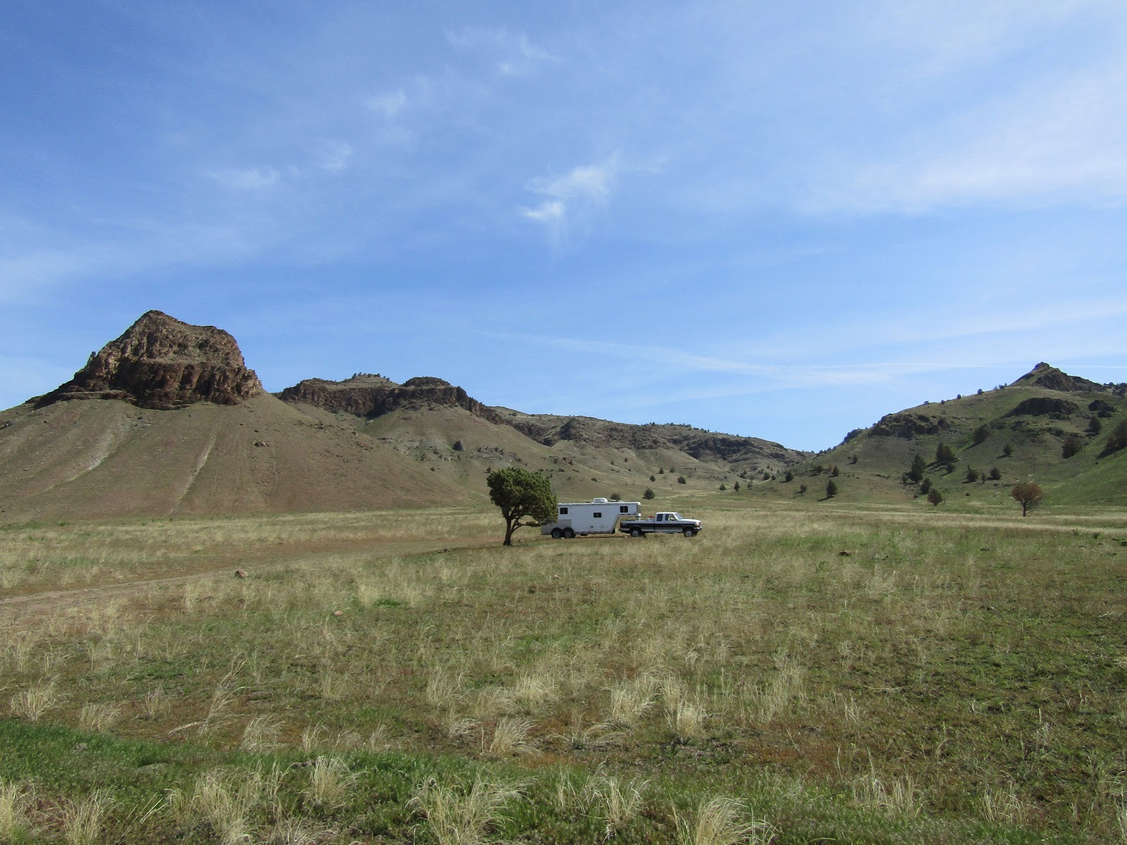
Spring Basin is on the way to Fossil OR, on Clarno Rd. which eventually dead ends. About 3 miles along it there is a small parking area next to a lone juniper and the trail runs straight uphill from there. This is where I camped, but about another 1/4 of a mile along Clarno Rd. they have put in a Spring Basin Wilderness Area sign board and there is some parking there as well. This is primitive camping with no amenities whatsoever.

Spring Basin Wilderness.

This wasn't an especially long drive from my home in Central OR so I got there with plenty of time to explore all day. There is an old jeep track that runs through the wilderness with a few offshoots here and there. I decided to ride to the end of Clarno Rd. where it starts, and then follow it all the way until it finally ends at the boundary to land that the Confederated Tribes of Warm Springs owns. There is a map online that shows the "trails" but they aren't really trails and they don't get much use, so in some areas the old road becomes very faint, although there are a few cairns set up here and there.

Heading up the old jeep track.

I passed by the spring that the area is named after, but there was not a whole lot of water coming out of it.
This is the time of year that the hedgehog cactus are blooming and I got to see lots of bright pink flowers as I rode. I went to a ridge over looking Hay Bottom Canyon, then continued on passing the trail that goes back downhill to where I parked, and kept going to Horse Mt and beyond. Once I reached the boundary signs I turned around, although there isn't a fence or any no trespassing signs, according to the map this is private property that you are supposed to stay off of.

Spring Basin Wilderness.

Spring Basin Wilderness.

The hedgehogs were blooming.

Looking down onto the John Day River.

The view from a cliff near where I turned around.

The next morning I drove over to Sutton Mt. passing by the Clarno Unit of the John Day Fossil Beds.

The Palisades at the Clarno Unit of the John Day Fossil Beds.

You would never see the Sutton Mt. trailhead if you didn't know where it was, but since it is right by mile marker 15 on Hwy 207 that makes it easier to describe. There is a large area along the highway where you can park, or you can drive in through a wire gate and park or camp there. Again there are no amenities, other than a creek for stock water that you would be sharing with cows.

The wire gate into the Sutton Mt. area.

Just through the wire gate there are camp spots. My rig is parked along the highway.

This is a straightforward follow the dirt road up to the top of the mountain ride, but when I had hiked it before I had always wondered where the road continued on to. So after admiring the views down onto the Painted Desert and looking for more hedgehog cactus, (they were there, but these ones were not blooming), I followed the road some more. It drops way downhill, passing a spring, a pile of lumber and an old stove that was once someone's home, then crosses a gully and heads back uphill rejoining itself eventually, so I was able to do a loop which I always like to do if possible.

Halfway up Sutton Mt.

Views from the trail up Sutton Mt.

Riding up Sutton Mt.

On Sutton Mt.

Looking way down from on top of Sutton Mt.

Originally I was thinking of spending the night there, but instead I decided to drive over to my next destination which was Pat's Cabin Wilderness Study Area. It's located on the opposite side of Sutton Mt. from where I was, and the BLM map showed the quickest route as leaving from a junction that was very close by. The route starts well and ends well but unbeknownst to me, the middle section becomes narrow, windy, and one lane gravel for quite some time. But once I was committed, there was no point in turning around. The legend on the BLM map shows this road as being a "main road" not even gravel. So that was completely inaccurate. There is another perfectly good way to get there along Burnt Ranch Road past the Painted Desert. At the sign for the recreation sites there is an old rickety cow corral, and that is where I parked. There are lots of other camping spots nearby but I thought I would take advantage of the handy corral for my horse's overnight stay. Once again no other amenities at this spot, although Bridge Creek is nearby, across the road.

The signs right near the corral where I camped on Burnt Ranch Rd.

The old corral on Burnt Ranch Rd. 

According to my not so accurate map, the trail into Pat's Cabin was supposed to be directly across the road. In the morning I headed over to the creek and saw that it was not going to be an easy crossing. I went up a small hill and tried to see if there was even a hint of a trail, or old road on the other side, and I saw nothing, so I decided to scrap that plan and ride to Priest Hole instead.
It's 3.5 miles of road riding to get there from where I was parked. I am really glad I decided to do this, because it turned out to be a lovely spot along the John Day River. Across the river there is another, not quite as big or spectacular, but beautiful none the less, version of hills similar to the Painted Desert. I'm sure this is a busy place in the summer, but other than one guy camping alone, I had the place to myself. I rode along the river for awhile and then rather than go back the same way I continued around on the loop road, and then back to my camp spot along Burnt Ranch Rd. A car passed me twice and finally the guy asked me if he was going in the right direction to get to Mitchell. I said "no Mitchell is the other way". His GPS was sending him on quite the wild goose chase.

Bridge Creek.

Road riding to Priest Hole.

Along the John Day River at Priest Hole.

At Priest Hole.

The John Day River at Priest Hole.

The John Day River at Priest Hole.

Priest Hole.

Some painted hills across the John Day River.

It was getting pretty hot so I was glad to be done my ride a little early, and so I drove home passing the Painted Desert on the way. I've seen this area before on previous hiking trips, so I did not stop this time, but it is certainly worth a visit.

The Painted Desert, my photo from a previous visit.

The Painted Desert, my photo from a previous visit.


GPS COORDINATES TO SPRING BASIN

GPS COORDINATES TO SUTTON MT. TH

GPS COORDINATES TO THE CORRAL ON BURNT RANCH RD.