Tuesday, April 19, 2016

Graham Corral Horse Camp, Deschutes National Forest, Oregon

Graham Corral is one of the horse camps in the Sisters area that can be accessed early in the season. The others are Sisters Cow Camp, and Sheep Springs which is over by Camp Sherman. Although I have never actually camped at Graham, since it is a short drive from my house, I have ridden there numerous times.

Fourmile Butte.

There are conflicting reports from various websites on when it officially opens, usually the beginning of May, but on Recreation.gov, they are accepting reservations after May 25th. However you can ride and camp there at any time of the year, just be prepared that there will not be water, or toilet paper etc. while it is closed.

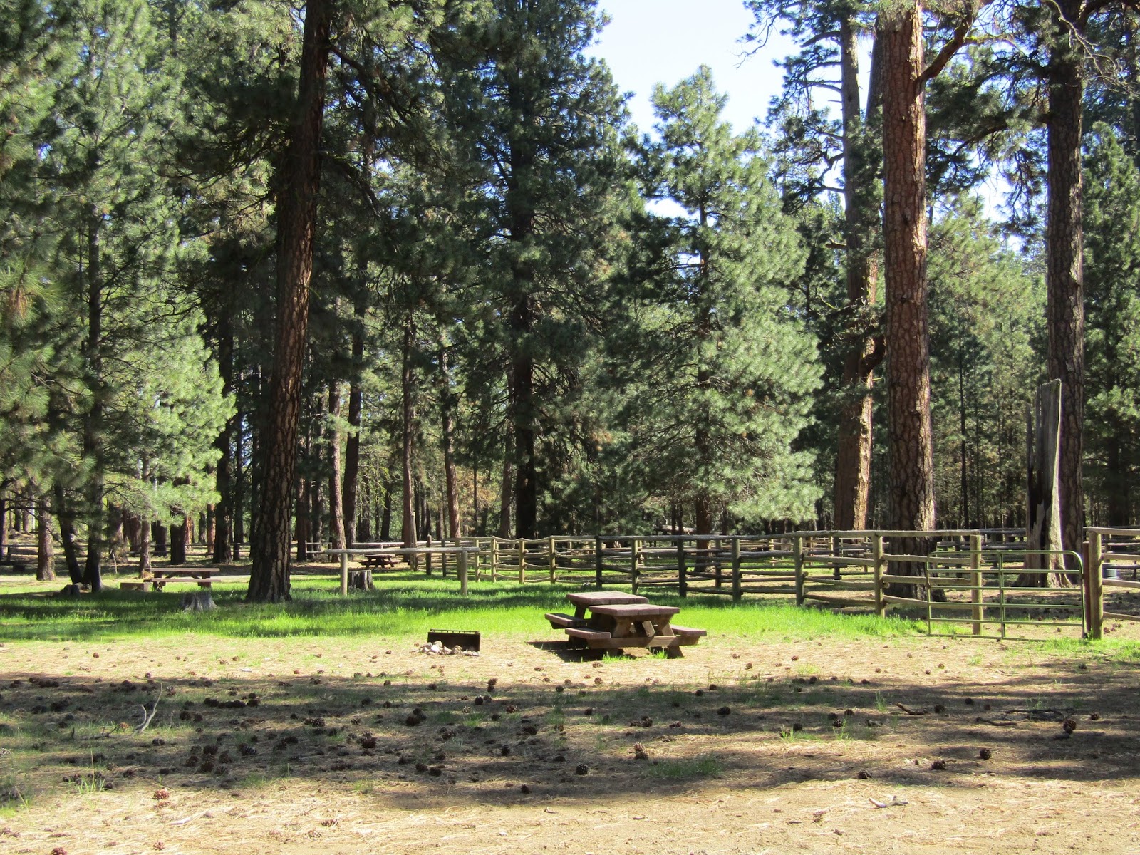
Graham Corral Horse Camp.

A friend once called the ranger station early in the spring, to ask when he could camp there, and was told it was gated and locked, this is NOT true. There is not even a gate to lock. Also the directions on Recreation.gov and on the forest service website take you on a longer gravel road from Hwy 242, this is completely unnecessary, when you can simply drive Hwy 20 west from Sisters for 5 miles then take a left where it is clearly signed. At that point you will be on gravel for almost 3 miles, continue to follow signs to the camp. The last part of the road is well taken care of, but the first half is a potholed mess, the worst I have seen it in recent years, and you can really only go about 5 mph. (They grade this road periodically, so it just depends on when you happen to be there)

The camp has 13 sites, but only 4 have corrals. However there are four very large communal corrals in the middle, and they have water troughs.
Site #4 has steel corrals, but the rest are wood. There is a bathroom, and it is $16.00 per night. Update: After a long time without any, as of 2024 there is a 1000 gallon tank of non potable stock water. There is a manure bin, and they now have a separate dumpster for manure with a ramp and a wheelbarrow.
There isn't really a designated day use area and you are no longer allowed to park in the camp unless you are actually staying there.

Graham Corral Horse Camp.

To do the Fourmile Butte ride, leave the camp heading south on the Metolius Windigo Trail, the sign will say to Sisters Cow Camp and Three Creek Meadow. You stay on the Met Win for awhile and then veer off to do the loop. This ride is clearly signed at junctions and marked the entire way with white diamonds.
Just follow along and enjoy the ride through tall Ponderosa.

The Met Win sign.

This trail is clearly marked and signed.

When you get to the butte, there is a sign that someone thought was a good idea to shoot the heck out of, and it will point the way to the left which is to the top of the butte, the white diamonds will continue to the right and that's where you will go after checking out the fantastic views on top. Speaking of shooting, I would recommend doing this ride during the week if possible, to avoid men with guns who may be up there.


The top of Fourmile Butte. View of Mt. Washington.

The top of Fourmile Butte, View of Mt. Washington.

The top of Fourmile Butte.

The top of Fourmile Butte, view of Black Butte.

The road back down Fourmile Butte.


After continuing on the loop, you will eventually get back on the Met Win and it takes you back to camp. This is an easy 10 mile ride.


The Met Win has yellow diamonds, as well as these markers.

Heading back to camp on the Met Win.

To go to Gobblers Knob which is a very scenic short 4.5 mile ride, head north on the Met Win from camp and follow the yellow diamonds. At one point after crossing a road there is a "private property, keep out "sign which someone placed directly on the trail, just ignore this, and continue on, but make sure not to wander off the trail during this section, so you are not trespassing.

Not really applicable, since this is a public trail.

Riding past Glaze Meadow you will see Gobblers Knob in front of Black Butte.

You will pass Glaze Meadow and then there will be two water crossings, after the second one the Met Win continues to the right, but this is where you will take a left into a fenced area, and then an immediate right, to follow the trail that skirts along the base of Gobblers Knob. Ignore any side trails, stay on the main one until you see some colored horseshoes on trees and then keep left to climb to the top of the hill. There are great views from the top, this time of year the meadow down below is a little dry, although it will be much greener soon.

Second water crossing.

Head through this fence to get to Gobblers Knob.

Nice views of the Sisters and Glaze Meadow from Gobblers Knob.

Atop Gobblers Knob.

From here you can head back the way you came, or continue around the rest of the knob. There is another meadow on the other side you can visit, this is really pretty with a lot of aspens. Black Butte Ranch has a dude string and they use these trails for their rides, so you can also explore for awhile following all the hoof prints. It is their colored horseshoes on the trees that mark the various loops they do.

The meadow on the north side of Gobblers Knob.

These are the two most scenic rides from camp, however, you can also ride to Sisters Cow Camp which is 12.5 miles round trip, or you can cross Hwy 20 on the Met Win and ride alongside Black Butte for as long as you want. There are also a number of dirt roads that I have followed for a long time, just exploring.
If you feel like an adventure you could try to find Skylight Cave, it is on FS Rd.260. If you get there at the right time of day and want to go into the cave, you might luck out and see the sunlight shining through the skylight.

Skylight Cave.


Happy Trails!

GPS COORDINATES TO GRAHAM CORRAL


Sunday, March 20, 2016

Peterson Ridge Trails, Sisters, Oregon

The Peterson Ridge Trail System is a series of horse, hiking, and biking trails. The bike trails are completely separate, so although you may see some cyclists as you ride, you won't be in close contact with them. However you will cross over their trails quite a bit, so it's good to keep an eye out for anyone coming.

Sisters Trails sign.

To get there: From Sisters take Hwy 20 east towards Bend for 4 miles, just after the rodeo grounds take a right on Peterson Ridge Rd.
From Redmond: Take Hwy 126 west towards Sisters for 16 miles, take a left on Cloverdale Rd for 3.5 miles, then a right onto Hwy 20, drive almost a mile and then take the left onto Peterson Ridge Rd.
From Bend: Take Hwy 20 west towards Sisters for just over 14 miles, then take a left on Peterson Ridge Rd.

Once you are on Peterson Ridge Rd which is a bumpy potholed gravel road, follow it half a mile and park on the right near the message board. You will be directly behind the Sisters rodeo grounds.

Parking directly behind the rodeo grounds.

This description is for the 12.5 mile ride to three viewpoints.
There are many signs and junctions along this route, but you can't go wrong if you just continue to follow the arrows and other markers that point you towards the various overlooks. There are maps in the map box, that you can take along with you.The first sign is right in the parking area, take the trail due west pointing towards Peterson Ridge Horse Trail.

The trail sign at the parking area.

After a short while the trail crosses over Harrington Loop Rd, and continues on the left side of the road.

 Harrington Loop Rd crossing.

The trail parallels the road most of the way then becomes a two track for awhile, then ends up back on the road. Keep following the white diamonds and you will shortly cross a second road. The trail continues on the other side and then turns into a dirt road that you stay left on.

The trail continues across this road.

Trails are marked with white diamonds.

At the next sign you reach, continue to the left up the hill, and then at the following sign the Lazy Z loop is straight ahead, which is another option for a shorter 8 mile ride, but for the viewpoint ride you need to go to the right.

From there just stay on the main trail, and you will get to the first viewpoint which is the Peterson Ridge Overlook. There is a convenient hitching rail if you want to tie up and wander around a little.

Hitching rail at Peterson Ridge Overlook.

Mountain views from the first overlook.

Continuing on, the trail crosses two red dirt roads in a row, after the second one the trail becomes dirt road 600. As you ride you will suddenly get a great view of North Sister. This is also where there is a new trail, on the left, that can be done as a short detour, to the Eagle Rock Two Viewpoint.


Mountain views from Eagle Rock Two Viewpoint.

Eagle Rock Two Viewpoint.

Back on the main trail the next junction you come to is the start of a loop, where you can either go left or right, for this description I went right.

Sign at the start of the loop.

You will get to the third viewpoint by following the sign towards Peak View.

Peak View.

Peak View.

Peak View.

Continue the rest of the loop, and then retrace your steps all the way back to the truck.

Some of the other riding options are: The aforementioned Lazy Z Loop, or you can just explore on random dirt roads in the area for miles. There is also a trail that goes from the rodeo grounds to Whychus Creek and beyond. In the spring after the water has gotten a little lower, you can cross the creek and continue to follow this to the Metolius Windigo Trail.

Rocks on the Peterson Ridge Loop.

Happy Trails!

GPS COORDINATES TO PETERSON RIDGE TH

Friday, March 4, 2016

Bessie Butte and Horse Butte, Deschutes National Forest, Oregon

After a lot of winter desert riding I am always happy to get into the national forest for a change.
This is a short but scenic ride to the top of Bessie Butte and back, but the Horse Butte area has many other trails to choose from.


Riding back down Bessie Butte.

The most straightforward way to get there, and without having to drive on a bouncy gravel road is: From Bend take Hwy 20 east towards Burns for one mile, take a right on Ward Rd, follow it 1.3 miles until it comes to a T, then take the left to stay on Ward. Continue another 2 miles then turn right on Billadeau Rd. When Billadeau crosses over Arnold Market Rd. the name changes to Horse Butte Rd. After 3.2 miles the pavement ends, and you will have several options for parking.

Immediately on the right there is a spot right next to Horse Butte, which is a bright red cinder cone. I usually park there, but on this particular day there was someone in the way, so I continued on gravel road 1815 for half a mile and then took a right on Rd. 800 at the sign for Horse Butte TH. There are several pullouts to choose from, or you can continue to the actual trailhead which is less than half a mile further. However the road gets a little more bumpy and washed out, so most people park along Rd 800. I parked in a large pullout on the right, a trail runs directly behind this to the trailhead or you can just ride down the road.

Trailhead sign on Rd 1815.

One of the parking areas, Horse Butte is behind me.

From the trailhead there is a sign for Swamp Wells Trail, follow this, and in not too long you will come to a junction sign, stay straight, it will be marked saying 2 miles to Bessie Butte. Don't be surprised if you hear gunshots while riding, there are two other buttes in the area, Cabin Butte and Coyote Butte that are very popular for shooting, I can say that in all the years I have ridden in this area, I have never NOT heard shooting, no matter the day, or time of year. However the trail systems are not that close to the buttes so it is more of an annoyance than a major safety issue.


Trailhead sign.

On the Swamp Wells Trail.

You will cross a couple of dirt roads along the way and then you will also cross paved China Hat Rd. The next junction is straight ahead and you will follow the trail to the right, to your destination which is in plain sight at this point.

Bessie Butte.

Climb up the butte and enjoy the views!

The trail up Bessie Butte.

You can ride around on top for a while. I didn't stay up there as long as I might normally, it was an especially gusty day and I was almost getting blown off my horse.

Mt. Bachelor from Bessie Butte.

On top of Bessie Butte.

Looking south towards Swamp Wells Horse Camp from Bessie Butte.

Eastern view of Cabin and Coyote Buttes.

Head back down the hill and retrace your steps back to your truck for an 8 mile total ride.

Since I am more of a stay out on the trail all day kind of girl, I continued on for a large loop of my own making, following some other trails and some dirt roads until I got to Boyd Cave. Here you can see for miles, due to most trees having been burned in a fire back in 1996. I have been into Boyd Cave a couple of times, it is a fun adventure to climb down and walk along the cave floor for half a mile. Near the end it narrows to the point where you have to get on your stomach and army crawl through to the next section. Not recommended for anyone who is claustrophobic!

Following roads to the south to do a big loop.

Snack time.

The entrance to Boyd Cave.

I continued on to Skeleton Cave, which is gated and closed to the general public, due to vandalism, although there are tours of the cave that occur seasonally. I then returned to my truck from there.

The road into Skeleton Cave.

Skeleton Cave.

Skeleton Cave is closed to the public.

This area is popular with cyclists, so a lot of times if faced with the choice of the actual trail or some of the two tracks that are out there, I will stay off the trails for two reasons, to avoid the cyclists, and I am apparently low on patience and would rather cut a straighter route to my destinations. A lot of these trails meander around quite a bit, and it takes three times longer to get anywhere on them!

On one of the two tracks, Horse Butte in the distance.

All of these other areas ( to Skeleton, Boyd Caves and beyond ) can be accessed from the same parking area as the Bessie Butte ride. The different trails are marked and numbered and the signs have mileage on them, so it is a good place to just get out and explore. There are even several different ways to ride all the way to Swamp Wells Horse Camp. Although it is not accessible quite yet at this time of year, since there is still snow up there, it is a good one to ride to, or start camping at, early in the season.

Another place you can ride to is Arnold Ice Cave.

Arnold Ice Cave, is still icy since the temperatures coming from underground keep it from melting.

Happy Trails!

GPS COORDINATES TO HORSE BUTTE