This was my third trip into the Wallowa's, and what I like best, besides the riding, is how accommodating all of the trailheads are for stock. Not only do they have large parking areas for trailers, but at every place I have been so far, they also have camping spots for people with horses, conveniently located just before the trailhead. Also since it is a long drive for me, burning lots of fuel, I like that the camps are all free....if you have a NW Forest Pass.
 |
| About to head up Ivan Carper Pass. |
My first day was just a driving day and once I got to Lostine I learned there are no gas stations there, so I had to continue on to Enterprise to fill up, where the diesel was not cheap. Had I known that I would have stopped in Elgin, I will most definitely remember that for next time!
The road to Two Pan Trailhead starts out paved, then turns to good gravel for awhile, but once I passed the Lostine Guard Station, it was one lane, and rocky with potholes which slowed me right down. Once I got there I pulled into the small horse camp that is on the left before the road ends at the trailhead.
 |
| The horse camp at Two Pan. |
Two Pan has 4 camp spots, although there is another parking spot that could easily be a 5th. One of the sites is quite large, in fact there was a trailer with a motorhome in it. I never saw them the whole time I was there, they had obviously just parked there and packed in.
I squeezed into another spot with maybe a foot to spare, so if you are longer than me, 39.5' total length, you would have to unhook. My site and the site with the motor home were plenty wide enough. There are some feeders and hitching rails, but no corrals. There is a bathroom with a small garbage bag in it at the trailhead, which is a short walk at the end of the road, and it is $5.00 a night to camp/park or free with a NW Forest Pass. The Lostine River is across the road, but it is not very easy to access if you are wanting to haul water.
There were a lot of cars in the parking lot and lining the side of the road, mostly because there were three outfitters rigs in the horse trailer parking area that had taken people in for pack trips, and of course some cars were from backpackers as well.
 |
| The trailhead at Two Pan. |
I got started riding bright and early the next day because I planned to do a long loop up the East Fork Lostine River, over Ivan Carper Pass, then down the West Fork Lostine River. This is 17 miles including a short detour stop at Mirror Lake. It's a long 17 miles because there is not a lot of opportunity to move faster than a walk. I loved this loop a lot, but it could also be done as two different out and back rides, without doing the pass, however the view from the pass is fantastic and well worth it. There are sections here and there with large boulders on the trail that you need to negotiate.
 |
| Starting out on the East Fork Lostine Trail. |
 |
| A waterfall on the East Fork Lostine Trail. |
At one point the trail split and if I had followed the right side it would have kept me in the trees, but the left side went through a meadow and was much more scenic.
 |
| The trail goes through a meadow for awhile. |
 |
| Seeing Eagle Cap in the distance on the East Fork Lostine Trail. |
 |
| More meadows along the river. |
 |
| Stopping for a snack before climbing up to Mirror Lake. |
 |
| This part of the trail is stunning, right below Eagle Cap. |
I did the detour over to Mirror Lake, which is where I saw the most people, since a lot of backpackers camp there. If I had continued following the trail past the lake, it leads into the lakes basin, and would be a great area for a pack trip. But I headed up the pass, where I could see Blue Lake from above, and once at the bottom of the pass, I arrived at Minam Lake. There was a fire burning in Granite Gulch which did not affect the trails I was on, but I did see some smoke plumes while on the pass.
 |
| Mirror Lake. |
 |
| The Matterhorn from Ivan Carper Pass. |
 |
| Looking down on Mirror Lake from Ivan Carper Pass. |
 |
| Smoke from the Granite Gulch fire. |
 |
| Heading down the pass towards Minam Lake. |
 |
| The West Lostine River, crystal clear water. |
The next day I rode half a mile back down the road to the trailhead for Maxwell Lake. This is a short ride, 7.8 miles, with no other destinations once you reach the lake. The trail starts off with some long easy switchbacks, but then it quits being nicey nice and the last mile is straight up!
This trail has some steep drop offs, and some narrow sections. On one of the narrow sections a lady and her daughter moved uphill off the trail so I could pass. As we were chatting the lady enthusiastically pointed over towards a view, while holding her hiking poles, and pretty much waved them right in my horse's face. In times like these I think about how another horse would have reacted to that, and I love my horse twice as much for not spooking and leaping off the cliff, she is worth her weight in gold!
Once at the lake I hung out and just enjoyed the quiet. I had seen three cars in the parking lot, and I had since passed all three hikers, and so I had the place to myself for awhile, until they caught up.
 |
| On the Maxwell Lake Trail. |
 |
| Almost to Maxwell Lake. |
 |
| Maxwell Lake. |
 |
| On the Maxwell Lake Trail. |
After completing that ride I packed up and drove to Irondyke Forest Camp which is very close to the Bowman Frances Trailhead, my destination for my next excursion.
Irondyke is a nice little camp with mostly non horse sites, but there are two specifically designated for equines. One is down off to the side and secluded near the river, and the other one, which I picked, is across the road. The weather was starting to turn a little funky and I wanted to be in the trees where I could set up my corral. Sure enough we had the first of many thunderstorms that evening. It is a free camp, with a NW Forest Pass, and there is a bathroom.
Update: As of 2022, they are charging $15.00 for the main campground now, my across the road spot, is the only one that is still free. My site has a picnic table, a homemade fire pit, and a hitching rail. Again, stock water is available from the river. I also found a water trough at the nearby trailhead, but it is not close enough to be very convenient.
 |
| Irondyke is close to the Bowman Frances Trailhead. |
 |
| The equestrian spot across the road, at Irondyke. |
My goal for the following day was to ride 13 miles to Laverty Lakes, Chimney Lake and then up to Hobo Lake. Other options from this trailhead are a long pack trip into the Wilson Basin, or what looks to be a very steep and long trail to Frances Lake.
Update: In 2022 I went back and rode the trail to Frances Lake, to read about it click here: Frances Lake. Chimney Lake was easier than the first two rides I had done, the trail was wider, and the climb was more gradual.
 |
| The wilderness sign on the Bowman Trail. |
 |
| On the Bowman Trail. |
 |
| On the Bowman Trail. |
 |
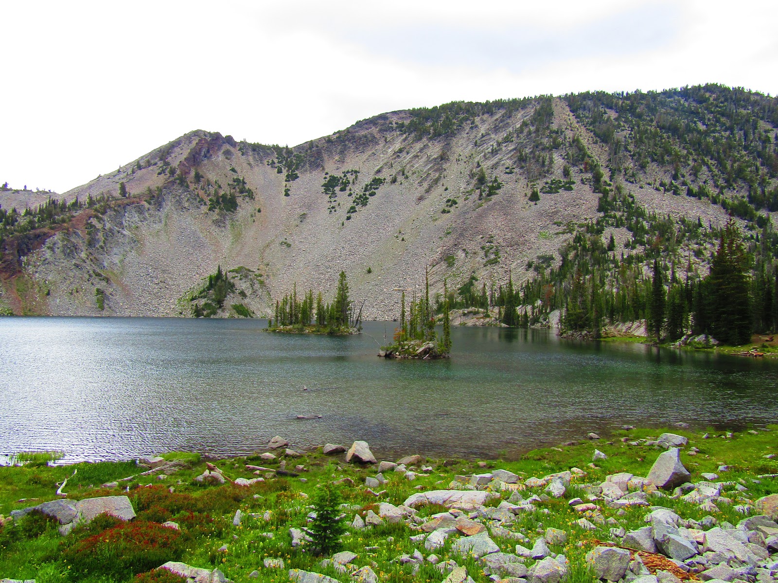
| Chimney Lake. |
When I got to Chimney Lake, the weather had changed and it seemed like another storm was brewing. There was another 1.5 mile climb to get to Hobo Lake and most of it was pretty exposed, so I contemplated whether to continue on or not. If you guessed that I did, you would be right.
Once I got to a saddle I had a very good view over towards Eagle Cap where one storm was blowing to the north and another nasty looking situation was happening over by Lostine. I watched everything for awhile and figured it wasn't heading my way so I scurried up to Hobo Lake.
By the time I got back down off the ridge, the storms were over, and I didn't get hit by anything other than some gusts of wind.
 |
| Hobo Lake. |
 |
| A viewpoint near Laverty Lakes. |
 |
| Laverty Lakes....can you spot my pony? |
Friday was a day off from riding and also a moving day. On the way back out I stopped at the Lostine Guard Station to refill my horse and trailer water. There is a convenient faucet there with potable water, also another one across the road that you can attach a hose to. I did not have a long enough hose, so I lugged water for quite some time.
 |
| The Lostine Guard Station has potable water! |
My next plan was to do a couple of easy rides in another section of the Eagle Cap outside of the town of Wallowa starting at Bear Creek Trailhead.
Boundary Campground is free, you don't even need a NW Forest Pass, and it has 2 equestrian spots.
Spot #1 is the better option because it is quite long with plenty of room, and has a feeder and a hitching rail. There is a bathroom at the campground and another bathroom with a small garbage bag, at the end of the road at the Bear Creek Trailhead. You can get stock water from Bear Creek, and it is close enough to easily haul to the camp sites.
There is plenty of parking at the trailhead, with a loading ramp and hitching rails, but you do need a pass to park there.
 |
| Spot #1 at Boundary Campground. |
 |
| Spot #1 at Boundary Campground. |
After another evening of thunderstorms, I rode early the next day, which turned out to be a really good idea, since the weather was only nice in the morning.
The Bear Creek Trail is nearly level the whole way with a few little ups and downs, and it follows the creek until you get to an unmarked junction, where a cabin is tucked away in the trees. This makes for a nice 10 mile out and back ride or you could continue on further since the trail keeps going and going and going. I turned around and got back to camp in time to get the last few things packed up, before the storm of the century hit me, lightning and thunder cracking overhead as I drove back to civilization.
 |
| Crossing the bridge on the Bear Creek Trail. |
 |
| Looking down onto Bear Creek. |
 |
| The Bear Creek Cabin. |
 |
| The only open area on the Bear Creek Trail, the rest is forested. |
Once I had cell service, I realized the forecast had changed, as it tends to do, and now Sunday was also going to be very stormy, so I scrapped my plan for going to the last trailhead, and instead drove part way back towards home stopping at Emigrant Springs State Park, which is conveniently located up in the Blue Mountains between La Grande and Pendelton.
Emigrant takes reservations and has 7 spots A through G. I ended up in what I will now call the "G Spot!".....which was the only pull through. E is big enough for a motorhome, and another person pulled into B with quite a long trailer. F is the worst spot since it does not really even have a parking area, you have to park parallel to the road. D and E are really close to each other and would be good for people travelling together.
There is a bathroom, (with lights on at night and Purell) a manure bin, garbage cans, a spigot that you can attach a hose to with potable water, and a grey water dump. There are brochures of the park at the kiosk and it is $17.00 per night. Each spot only has one larger than normal corral, they actually say you can fit as many as 4 horses in each corral but....not really....there is not enough room to cram that many in. My spot was the farthest from the highway, but with the traffic noise you will not find it to be a quiet place. If you feel like a bit of a walk, there are showers in the people campground.
 |
| The "G spot" at Emigrant Springs State Park. |
It's a pretty big area so I entertained myself that evening exploring the park and eating all the thimbleberries I could find. Pioneers on the Oregon Trail used to stop at the spring to get water, so there is some history to read about.
 |
| A plaque in the park about the Oregon Trail. |
In the morning after yet another evening of storms, the day was not looking bright and sunny, but I decided to do a short ride anyway. There is one equestrian trail that circles the perimeter of the park, but it is quite short. However there are numerous exits off of that trail into the national forest and so that is where I ended up riding, along a gas pipeline. Other trails have been made in the forest, but they mostly veer off the pipeline for awhile, meander around and the rejoin the pipeline eventually.
I didn't get a chance to explore much more of the area since I rode as far south as I could, at which point I came across a locked gate, then the rain which had been more like a mist, started up in earnest and so we hightailed it back to camp, getting drenched in the process.
 |
| On the equestrian trail in the park. |
 |
| Out on the gas pipeline. |
 |
| Came across some cows on the gas pipeline. |
After changing into dry clothes, my soggy pony and I hit the road, once we were out of the mountains, it was perfectly nice weather the rest of the way home. When I got back a friend informed me of the crazy storms that had happened in my absence, including a hailstorm where a snowplow had to clear it all off of the road, and a car that got struck by lightning and had a hole in the windshield. So all in all, my time away was less dramatic in comparison.
GPS COORDINATES TO TWO PAN
GPS COORDINATES TO IRONDYKE
GPS COORDINATES TO BOUNDARY
GPS COORDINATES TO EMIGRANT


No comments:
Post a Comment