Sunday, October 28, 2018

Cultus Corral Horse Camp, Three Sisters Wilderness, Oregon


Cultus is one of those camps that gets overlooked in favor of Quinn Meadows which is close by. It's one downfall is that although there are several nice loops with a lot of lakes, most of the rides require a short trailer trip to get to, or a lot of added riding mileage.

Kershaw Lake.

Cultus is a really nice camp with 11 level spots that have steel corrals except for spot #4 which has a highline. There is a bathroom with garbage cans, a manure bin with a wheelbarrow,
and potable water from a hand pump. You can also get stock water from the Cultus River, although it is a bit of a trek to get to it. Most sites are sizeable enough for larger rigs. There is a separate day use area but you have to be careful where you park, since it is heavily treed and the corners are sharp. It is $14.00 per night and it is not a gated camp, so it can still  be accessed when it is officially closed.

To get there:
From Bend, drive south on Hwy 97 and take exit 153 towards Sunriver.
Follow this road ( it eventually becomes Spring River Rd.) for almost 7 miles
and take a left on Forest Service Rd. 40, following a sign that says Cultus Lake.
Continue on Rd. 40 for 15 miles until it ends, then take a left, go almost a mile and take a right
on Rd. 4635 into the Cultus Lake area. After almost a mile take a right at the sign for the horse camp, follow the gravel road another mile, and the camp will be on the right.

Cultus Corral Horse Camp.

Cultus Corral Horse Camp.

Day use parking at Cultus Corral.

The Cultus River is nearby.

The Benchmark Butte Trail leaves from camp and it is a mostly forested ride that takes you over the butte, to the Corral Swamp Trailhead. The Corral Swamp Trail will loop you back to Cultus Lake. And then from there you take the Winopee Tie Trail back to camp for a 15 mile ride.

The Corral Swamp Trailhead.

On the Corral Swamp Trail.

Cultus Lake.

There are also a few riding options which leave from Little Cultus Lake's day use area, a 4 mile drive from the horse camp, where parking is limited. One of the rides is on the Many Lakes Trail and the Deer Lake Trail. This is a 12 mile loop or you can extend it by taking a short detour over to Irish and Taylor Lakes where you meet up with the PCT. I have followed the PCT north from there as far as Brahma Lake. You can also take the trailhead from Rd. 4636 over towards Charlton Lake.

Kershaw Lake on the Many Lakes loop.

The Three Sisters Wilderness sign.

Brahma Lake.

Watching kayakers on Little Cultus Lake, from the Deer Lake Trail.

Another nice ride is over to Winopee Lake  which is a 15 mile out and back, and passes by an old cabin at Muskrat Lake. This is a 2.5 mile drive from camp or you can ride there on the Winopee Tie Trail. There is a very large paved area at the boat ramp at Cultus Lake, which is the best place to park, since the actual trailhead is quite small.

The cabin at Muskrat Lake.

Winopee Lake.


For downtime in between rides, Cultus Lake has a resort with a restaurant, store, and watercraft rentals, and the lake is really nice for swimming.

Happy Trails!


GPS COORDINATES TO CULTUS

Saturday, September 29, 2018

Kalama Horse Camp, (Mt. St. Helens) Washington

I had a completely different trip planned for the end of September but weather forced me to change my mind, as it sometimes does, so I decided to head over to Kalama Horse Camp in the Mt. St. Helens National Volcanic Monument. I had camped there before in July of 2009, but I am glad I went back again because we did not ride all of the trails the first time, the deer and horse flies were abundant, and I remember nearly getting eaten alive by mosquito's. But at this time of year there were no problems with insects, and after a few previous days of rain, the trails were dust free.

View of Mt. St. Helens at Red Rock Pass.

The Monument sign past the horse camp.

Kalama is a big camp with 27 sites to choose from. Sites 1-10 are in the first loop and 11-27 are in another lower loop. You can be in the first loop, like I was, and not even know anyone else is camped in the other area, since they are pretty far apart. Spots #1 and #2 are group sites.

The first loop has mostly log corrals, although two sites have steel, there is a composting toilet, and three manure bins complete with wheelbarrows and pitch forks. This is where the day use area is and where the trailheads start, and there is a loading ramp, mounting assist, and a snow shelter. There are also some hitching rails and a stock water trough, fed from the nearby river. A lot of trees have recently been cut down so there is also a lot of firewood stacked around the camp.

The second loop has log corrals, three manure bins, a bathroom, a mounting assist, and a stock water tank. You can now get reservations for this camp, and most sites are pull through's which are plenty large enough for longer rigs. There is no garbage service or potable water. Update: As of 2020, they now have a camp host, and fees have gone up from $8 to $18 per night. Also 10 campsites have now been designated for non horse people.

Spot #3 in the upper loop.

The day use area is where the trailheads start and where the stock water is.

There is a mapboard at the trailhead, but I prefer the more detailed map I printed out and brought from home, which I got on wacmo.org.

I arrived around midday and decided to do the Fossil Trail first, since it is not as long as some of the other trails. It climbs quite steeply for awhile up along Goat Mt. then levels out and drops down the other side briefly. I was going to ride until the trail's end, but I had to reconsider when I got to a creek crossing with a bridge that was under construction. There had been a warning sign about this at the trailhead which said that the construction was to have been finished a few days before I arrived, but clearly that was not the case. I found a side trail down to the creek, but the bank on the other side looked tricky to try to scale, and I was pretty sure I wasn't missing anything incredibly exciting on the last mile or so of trail, so I turned around.

On the Fossil Trail.

Some fall colors on the Fossil Trail.

After climbing for awhile the Fossil Trail levels out.

My horse is asking "what do we do now mom?"

The following day was foggy all morning, but I rode up Cinnamon Peak on the Cinnamon Trail, which is another good climb in elevation. Once I got to the top there was an unsigned junction, it was obvious the loop continued to the right, however I turned left briefly, just out of curiosity. It came out into a small clearing, the fog magically parted, and I got my first glimpse of Mt. St. Helens. 

The bridge over the Kalama River.

Riding in the fog on the Cinnamon Trail.

The fog cleared a little, just in time for a glimpse of Mt. St. Helens.

I headed back down Cinnamon Peak and was going to loop back along the river on the Toutle Trail but first I took a little side trip onto the lava at Red Rock Pass, because I recalled there being a great mountain view from there.

Almost to the bottom of the Cinnamon Trail.

Mt. St. Helens from Red Rock Pass.

On the Toutle Trail.

The Kalama River from the Toutle Trail.

On day three I knew I was either going to do a pretty long ride, or an even longer ride, depending on how things went. I started on the Kalama Ski Trail, then got onto another section of the Toutle Trail on the way to Blue Lake. From there I continued to loop around coming back down the Blue Horse Trail. At that point I could have headed back to camp, but I chose to extend the ride by doing more sections of the Toutle and Kalama Ski Trails and then back along the road instead of retracing my steps from earlier, making this about a 20 mile day.

On the Kalama Ski Trail.

On the Toutle Trail heading towards Blue Lake.

Blue Lake shows it true color from up above.

Shrooms on the Toutle Trail.

Junctions are marked.

On my last day I did the short trail, (about 7 miles ) over to Kalama Falls. This heads downhill and once you reach the area where the falls are, which is on a road, there is a sign to show you where to go. You have to tie up your horse and hike in from there. Be prepared to climb down a steep hill, there is a rope to haul yourself back up on, and cross a log over the water.

On the last part of the trail to Kalama Falls.

Signage for Kalama Falls.

The tie up area at Kalama Falls.

Kalama Falls.

I then packed up and started my five hour drive back to my home, glad that the weather cooperated, and that the riding was great for my last trip of this year!


GPS COORDINATES TO KALAMA


Sunday, September 9, 2018

Pamelia Lake, and Big Meadows Horse Camp,Oregon

It seemed like a long time in between camping trips, an injured horse, fires burning everywhere, extreme heat, and so on and so forth. Finally I was able to get away for a few days. My plan was to go to Santiam Horse Camp, but since this camp only has one trail, I was also going to do a ride on the way there and on the way back. If you are wondering why the title of this blog says Big Meadows instead of Santiam, all will be explained ....stay tuned.

On the Turpentine Trail from Big Meadows Horse Camp.

I started at the Pamelia Lake Trailhead which is a limited entry area so you need to get a permit. It is $10.00 a day and you can buy it on Recreation.gov, print it out, and bring it with you.
I wanted to wait until September to do this trail, since the parking lot isn't very big, and getting turned around could be an issue if there are a lot of cars parked there.
I was only the fourth vehicle to arrive on a Tuesday morning so I got situated with ease and set off up to Pamelia Lake. The first part of the trail is easy, but after getting to the lake I also wanted to ride up into Hunts Cove and potentially do a 16 mile loop back down the PCT. On the way to Hunts Cove the trail becomes a little less horse friendly, a lot of sketchy looking bridges with no way to cross the water other than on the bridge, a lot of small ditches made from large rocks, and then a boulder section of the trail with a very small passageway between rocks, that my horse barely made it through.

The Pamelia Lake Trailhead.

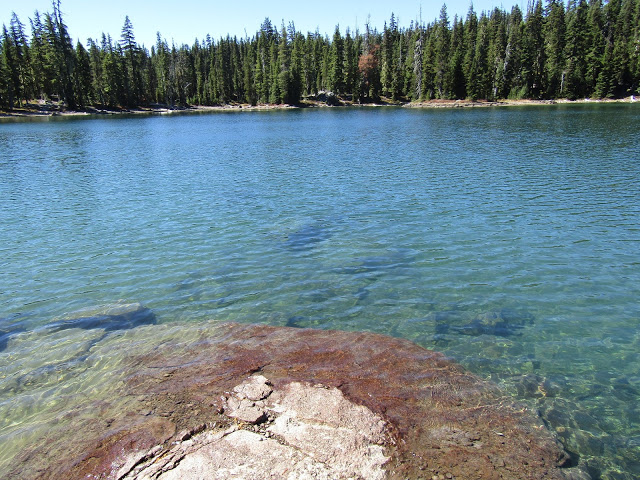
Pamelia Lake and Grizzly Peak.

Pamelia Lake.

One of the sketchy bridges on the Hunts Creek Trail.

On the Hunts Creek Trail, a little glimpse of Mt. Jefferson.

Once I got to Hanks Lake the trails stopped being cleared, and in order to get to Hunts Lake a little further up, I had to get off and lead my horse up a vertical hill because of a downed tree blocking the trail. Shortly after that, back down the same hill we came, when I realized that although the PCT was so close, I was not going to actually get to it that day, and so I had no choice but to go back the same way. Back at the boulder section, I realized from that direction my horse wasn't going to make it through safely, so I tried to move some of them to make more room, but had no luck, so instead I led my horse down the cliff and skirted the whole boulder field. Needless to say it was an adventurous day, I felt like I was getting on and off my horse more than I was actually riding her.

Hanks Lake at Hunts Cove.

Hunts Lake at Hunts Cove.

I then innocently drove over to Santiam Horse Camp, expecting it to be open, since all the info online had stated it was open until October. Only to find it gated and closed. This was twice as irritating since this had already happened to me once before about four years ago. I had gotten there before it opened in the spring, got to the locked gate and had to back down the dirt road in the dark. At least this time as I was backing out of there yet again, it was in the daylight.
Nonetheless I was slightly cranky as I drove back towards home, since it is never fun to drive way out of the way for no reason, and I had none of my normal gear with me to do any dispersed camping elsewhere, so I made the quick decision to stop at Big Meadows instead.

Big Meadows has nine spots with log corrals except for spot #8 which has steel corrals. There is also an additional spot that is not numbered with room for more than one rig. The other sites are only wide enough for one vehicle, but they are plenty long enough for bigger rigs except for site #1 which is the shortest. There are two bathrooms with garbage cans, two manure bins, and three options for water. A hand pump with potable water, stock water from the creek or a spring fed water trough that is set up right next to the creek. There is a day use area with a loading ramp, and it is $14.00 per night, at this first come, first serve camp.

Spot # 2 at Big Meadows Horse Camp.

 About 8 years ago I camped at Big Meadows and did the Turpentine Trail, and I was hoping it was cleared this time as well, and indeed it was. There are no maps or signage from camp so you kind of already need to know where to go. But the easiest way to explain it is: there is a main trailhead from camp that heads towards Duffy Lake, and branching off from it, there are a couple of marked junctions that take you to the Turpentine Trail. Or you can ride the paved FS Rd 2257 past the camp where you can get to the Big Meadows Loop and the other end of the Turpentine Loop. Someone has helpfully put a few small signs up on trees at road junctions. On my way back I also did the short side trip up to see Pika and Fir Lakes.

On the Turpentine Trail.

On the Turpentine Trail.

On the Turpentine Trail.

Fall colors at Pika Lake.

A large toad on the way to Fir Lake.

Fir Lake.

On my last day I started on the Big Meadows Loop, which has some of the prettiest forest in the area. It does pass by one large meadow, however you only get a brief glimpse of it through the trees. I tried to access it from a side trail but it was too brushy around the perimeter to get out into the open area.

The last part of this loop goes along a creek for awhile and as I was heading down a hill I spied a bear on the other side. He looked like a young bear to me, and he was unaware of my presence because of the noise from the creek. My horse and I watched him for quite awhile as he happily munched his way through all the huckleberries, and then eventually wandered off.
After finishing up this ride I continued on and also did the Snow Shelter Loop that leaves from camp and is marked with yellow diamonds. The same someone ( I assume) who put up the small signs in various places, drew a nice map and put it on a tree, so you can check it out before leaving. This loop follows cross country ski trails over to Maxwell Butte Snow Park and then up to the Mountain View Snow Shelter. Normally from there you would actually see the mountains, but I was dealing with some smoke drifting in from the south, so I just saw vague outlines.

On the Big Meadows Loop Trail.

Somebody drew a handy map for the Snow Shelter Loop Trail.

On the Snow Shelter Loop.

At the Mountain View shelter.

Inside the Mountain View shelter.

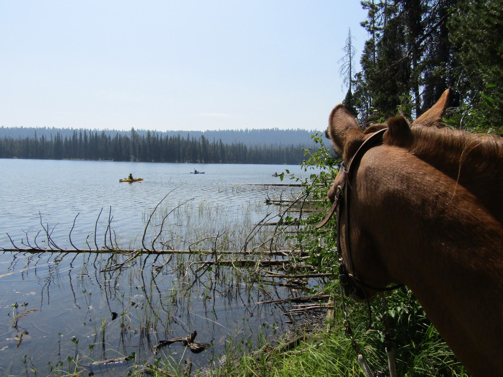
Some of the most scenic riding is up to Duffy Lake and beyond. You can also visit Mowich Lake, North and South Dixie Lakes, and the very beautiful Santiam Lake with Three Fingered Jack.
I had just done this ride from the PCT Trailhead at Santiam Pass, a week and a half before, so I did not ride up there again.
After passing Mowich you can also drop down into the Eight Lakes Basin and do another loop in there, which would be a pretty long ride from camp. That was actually what I had originally planned to do on my way back from Santiam, starting from the Marion Lake Trailhead. But this year part of the loop has not been cleared, so I am hoping next time I head over there, it will be logged out.

Duffy Lake.

Mowich Lake.

Santiam Lake with Three Fingered Jack.

What's nice about this camp is the trails are not difficult, and you have the choice of doing short loops, or combining more than one in a day in order to do longer rides, which is what I did.

Happy Trails!

GPS COORDINATES TO PAMELIA LAKE TH

GPS COORDINATES TO BIG MEADOWS